You are here: Home > Network List > O2 - Oklahoma Consolidated Temporary Seismic Networks Stations List
> Station MRSH Marshall, Oklahoma, USA > Earthquake Result Viewer
MRSH Marshall, Oklahoma, USA - Earthquake Result Viewer
| Earthquake location: |
Fox Islands, Aleutian Islands |
| Earthquake latitude/longitude: |
53.1/-166.6 |
| Earthquake time(UTC): |
2022/01/22 (022) 05:17:03 GMT |
| Earthquake Depth: |
3.0 km |
| Earthquake Magnitude: |
6.3 Mi |
| Earthquake Catalog/Contributor: |
NEIC PDE/at |
|
| Network: |
O2 Oklahoma Consolidated Temporary Seismic Networks |
| Station: |
MRSH Marshall, Oklahoma, USA |
| Lat/Lon: |
36.13 N/97.70 W |
| Elevation: |
309 m |
|
| Distance: |
49.9 deg |
| Az: |
80.864 deg |
| Baz: |
312.644 deg |
| Ray Param: |
0.06843807 |
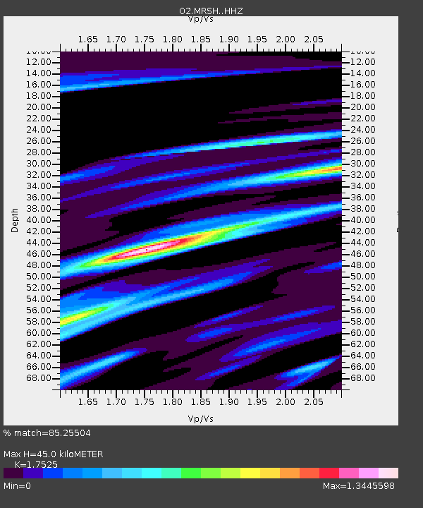
| Estimated Moho Depth: |
45.0 km |
| Estimated Crust Vp/Vs: |
1.75 |
| Assumed Crust Vp: |
6.483 km/s |
| Estimated Crust Vs: |
3.699 km/s |
| Estimated Crust Poisson's Ratio: |
0.26 |
|
| Radial Match: |
85.25504 % |
| Radial Bump: |
384 |
| Transverse Match: |
64.327835 % |
| Transverse Bump: |
357 |
| SOD ConfigId: |
26694651 |
| Insert Time: |
2022-02-05 05:40:56.426 +0000 |
| GWidth: |
2.5 |
| Max Bumps: |
400 |
| Tol: |
0.001 |
|

Signal To Noise
| Channel | StoN | STA | LTA |
| O2:MRSH: :HHZ:20220122T05:25:26.704987Z | 7.189051 | 1.3587738E-6 | 1.89006E-7 |
| O2:MRSH: :HHN:20220122T05:25:26.704987Z | 2.1613681 | 7.933583E-7 | 3.67063E-7 |
| O2:MRSH: :HHE:20220122T05:25:26.704987Z | 3.9071648 | 7.41188E-7 | 1.8969969E-7 |
| Arrivals |
| Ps | 5.5 SECOND |
| PpPs | 18 SECOND |
| PsPs/PpSs | 24 SECOND |


