You are here: Home > Network List > O2 - Oklahoma Consolidated Temporary Seismic Networks Stations List
> Station SC19 Bison, Oklahoma, USA > Earthquake Result Viewer
SC19 Bison, Oklahoma, USA - Earthquake Result Viewer
| Earthquake location: |
Fox Islands, Aleutian Islands |
| Earthquake latitude/longitude: |
53.1/-166.6 |
| Earthquake time(UTC): |
2022/01/22 (022) 05:17:03 GMT |
| Earthquake Depth: |
3.0 km |
| Earthquake Magnitude: |
6.3 Mi |
| Earthquake Catalog/Contributor: |
NEIC PDE/at |
|
| Network: |
O2 Oklahoma Consolidated Temporary Seismic Networks |
| Station: |
SC19 Bison, Oklahoma, USA |
| Lat/Lon: |
36.22 N/97.84 W |
| Elevation: |
1116 m |
|
| Distance: |
49.7 deg |
| Az: |
80.886 deg |
| Baz: |
312.571 deg |
| Ray Param: |
0.0685356 |
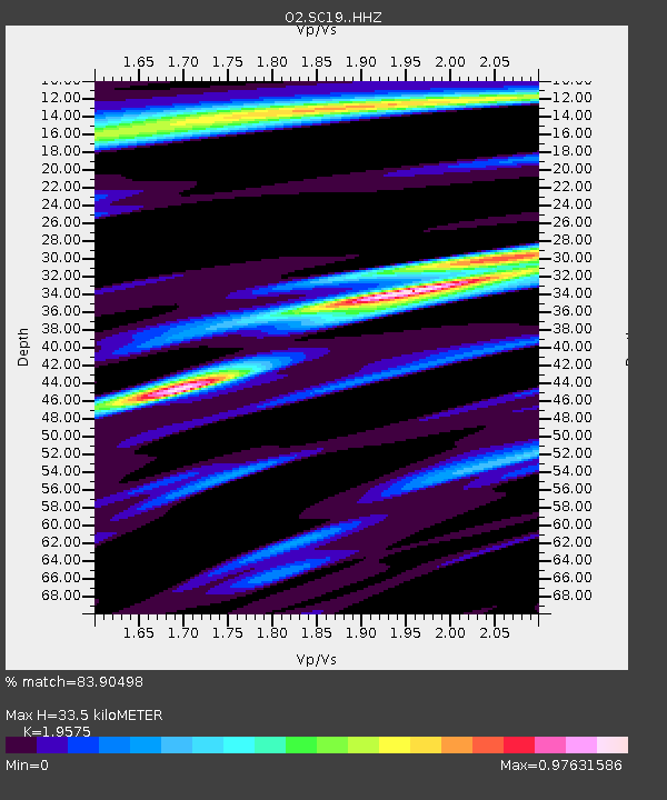
| Estimated Moho Depth: |
33.5 km |
| Estimated Crust Vp/Vs: |
1.96 |
| Assumed Crust Vp: |
6.483 km/s |
| Estimated Crust Vs: |
3.312 km/s |
| Estimated Crust Poisson's Ratio: |
0.32 |
|
| Radial Match: |
83.90498 % |
| Radial Bump: |
306 |
| Transverse Match: |
53.584038 % |
| Transverse Bump: |
324 |
| SOD ConfigId: |
26694651 |
| Insert Time: |
2022-02-05 05:41:46.121 +0000 |
| GWidth: |
2.5 |
| Max Bumps: |
400 |
| Tol: |
0.001 |
|

Signal To Noise
| Channel | StoN | STA | LTA |
| O2:SC19: :HHZ:20220122T05:25:25.579987Z | 4.5193477 | 1.1576387E-6 | 2.5615174E-7 |
| O2:SC19: :HHN:20220122T05:25:25.579987Z | 2.2897508 | 5.3721345E-7 | 2.3461656E-7 |
| O2:SC19: :HHE:20220122T05:25:25.579987Z | 1.6762094 | 5.1240454E-7 | 3.0569242E-7 |
| Arrivals |
| Ps | 5.2 SECOND |
| PpPs | 14 SECOND |
| PsPs/PpSs | 20 SECOND |


