You are here: Home > Network List > OK - Oklahoma Seismic Network Stations List
> Station BLOK Blackwell, Oklahoma, USA > Earthquake Result Viewer
BLOK Blackwell, Oklahoma, USA - Earthquake Result Viewer
| Earthquake location: |
Fox Islands, Aleutian Islands |
| Earthquake latitude/longitude: |
53.1/-166.6 |
| Earthquake time(UTC): |
2022/01/22 (022) 05:17:03 GMT |
| Earthquake Depth: |
3.0 km |
| Earthquake Magnitude: |
6.3 Mi |
| Earthquake Catalog/Contributor: |
NEIC PDE/at |
|
| Network: |
OK Oklahoma Seismic Network |
| Station: |
BLOK Blackwell, Oklahoma, USA |
| Lat/Lon: |
36.76 N/97.22 W |
| Elevation: |
301 m |
|
| Distance: |
49.8 deg |
| Az: |
79.917 deg |
| Baz: |
312.317 deg |
| Ray Param: |
0.06852939 |
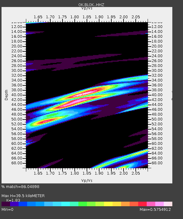
| Estimated Moho Depth: |
39.5 km |
| Estimated Crust Vp/Vs: |
1.83 |
| Assumed Crust Vp: |
6.483 km/s |
| Estimated Crust Vs: |
3.542 km/s |
| Estimated Crust Poisson's Ratio: |
0.29 |
|
| Radial Match: |
86.04898 % |
| Radial Bump: |
400 |
| Transverse Match: |
66.403534 % |
| Transverse Bump: |
400 |
| SOD ConfigId: |
26694651 |
| Insert Time: |
2022-02-05 05:42:30.730 +0000 |
| GWidth: |
2.5 |
| Max Bumps: |
400 |
| Tol: |
0.001 |
|

Signal To Noise
| Channel | StoN | STA | LTA |
| OK:BLOK: :HHZ:20220122T05:25:25.654999Z | 3.4893029 | 7.6294054E-7 | 2.1865128E-7 |
| OK:BLOK: :HHN:20220122T05:25:25.654999Z | 2.5106106 | 3.884868E-7 | 1.5473798E-7 |
| OK:BLOK: :HHE:20220122T05:25:25.654999Z | 2.3982615 | 5.1202693E-7 | 2.1349918E-7 |
| Arrivals |
| Ps | 5.4 SECOND |
| PpPs | 16 SECOND |
| PsPs/PpSs | 22 SECOND |


