You are here: Home > Network List > US - United States National Seismic Network Stations List
> Station OGNE Ogallala, Nebraska, USA > Earthquake Result Viewer
OGNE Ogallala, Nebraska, USA - Earthquake Result Viewer
| Earthquake location: |
Fox Islands, Aleutian Islands |
| Earthquake latitude/longitude: |
53.1/-166.6 |
| Earthquake time(UTC): |
2022/01/22 (022) 05:17:03 GMT |
| Earthquake Depth: |
3.0 km |
| Earthquake Magnitude: |
6.3 Mi |
| Earthquake Catalog/Contributor: |
NEIC PDE/at |
|
| Network: |
US United States National Seismic Network |
| Station: |
OGNE Ogallala, Nebraska, USA |
| Lat/Lon: |
40.95 N/102.03 W |
| Elevation: |
1054 m |
|
| Distance: |
44.2 deg |
| Az: |
78.912 deg |
| Baz: |
308.618 deg |
| Ray Param: |
0.07210511 |
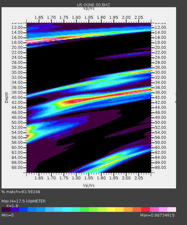
| Estimated Moho Depth: |
17.5 km |
| Estimated Crust Vp/Vs: |
1.60 |
| Assumed Crust Vp: |
6.483 km/s |
| Estimated Crust Vs: |
4.052 km/s |
| Estimated Crust Poisson's Ratio: |
0.18 |
|
| Radial Match: |
93.59246 % |
| Radial Bump: |
273 |
| Transverse Match: |
82.34474 % |
| Transverse Bump: |
391 |
| SOD ConfigId: |
26694651 |
| Insert Time: |
2022-02-05 05:50:43.814 +0000 |
| GWidth: |
2.5 |
| Max Bumps: |
400 |
| Tol: |
0.001 |
|

Signal To Noise
| Channel | StoN | STA | LTA |
| US:OGNE:00:BHZ:20220122T05:24:42.174988Z | 13.4654875 | 2.4194999E-6 | 1.7968158E-7 |
| US:OGNE:00:BH1:20220122T05:24:42.174988Z | 2.2988424 | 1.2036097E-6 | 5.235721E-7 |
| US:OGNE:00:BH2:20220122T05:24:42.174988Z | 3.9855776 | 1.7162706E-6 | 4.306203E-7 |
| Arrivals |
| Ps | 1.7 SECOND |
| PpPs | 6.5 SECOND |
| PsPs/PpSs | 8.3 SECOND |


