You are here: Home > Network List > UW - Pacific Northwest Regional Seismic Network Stations List
> Station IRON Crane, OR, USA > Earthquake Result Viewer
IRON Crane, OR, USA - Earthquake Result Viewer
| Earthquake location: |
Fox Islands, Aleutian Islands |
| Earthquake latitude/longitude: |
53.1/-166.6 |
| Earthquake time(UTC): |
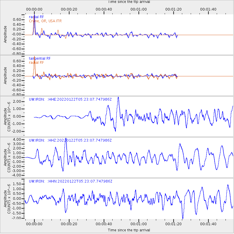
2022/01/22 (022) 05:17:03 GMT |
| Earthquake Depth: |
3.0 km |
| Earthquake Magnitude: |
6.3 Mi |
| Earthquake Catalog/Contributor: |
NEIC PDE/at |
|
| Network: |
UW Pacific Northwest Regional Seismic Network |
| Station: |
IRON Crane, OR, USA |
| Lat/Lon: |
43.36 N/118.47 W |
| Elevation: |
1226 m |
|
| Distance: |
32.9 deg |
| Az: |
87.458 deg |
| Baz: |
304.301 deg |
| Ray Param: |
0.07846141 |
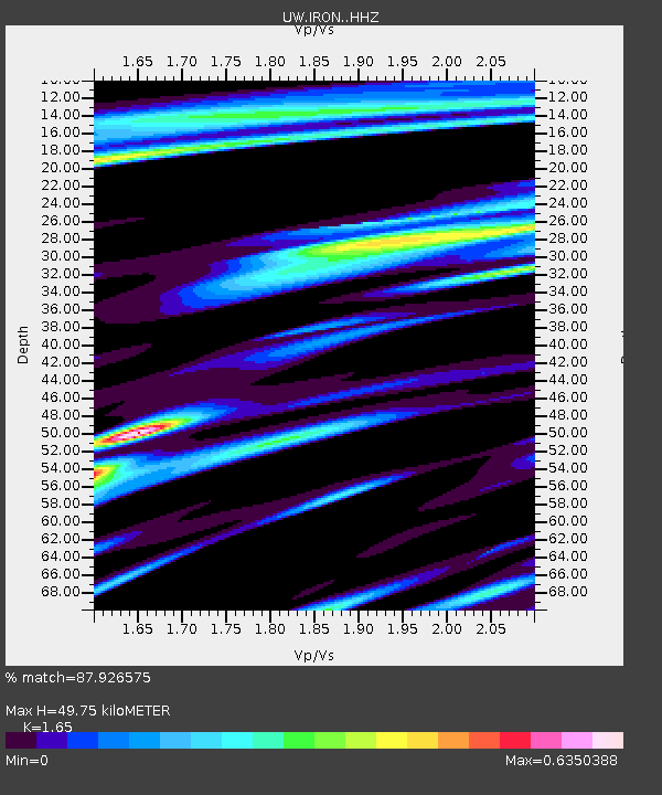
| Estimated Moho Depth: |
49.75 km |
| Estimated Crust Vp/Vs: |
1.65 |
| Assumed Crust Vp: |
6.279 km/s |
| Estimated Crust Vs: |
3.805 km/s |
| Estimated Crust Poisson's Ratio: |
0.21 |
|
| Radial Match: |
87.926575 % |
| Radial Bump: |
272 |
| Transverse Match: |
62.251064 % |
| Transverse Bump: |
400 |
| SOD ConfigId: |
26694651 |
| Insert Time: |
2022-02-05 05:51:35.029 +0000 |
| GWidth: |
2.5 |
| Max Bumps: |
400 |
| Tol: |
0.001 |
|
Signal To Noise
| Channel | StoN | STA | LTA |
| UW:IRON: :HHZ:20220122T05:23:07.747986Z | 5.115894 | 1.0144992E-6 | 1.9830341E-7 |
| UW:IRON: :HHN:20220122T05:23:07.747986Z | 1.5579237 | 2.3996108E-7 | 1.5402621E-7 |
| UW:IRON: :HHE:20220122T05:23:07.747986Z | 2.9720507 | 3.8099247E-7 | 1.2819179E-7 |
| Arrivals |
| Ps | 5.6 SECOND |
| PpPs | 19 SECOND |
| PsPs/PpSs | 25 SECOND |


