You are here: Home > Network List > BK - Berkeley Digital Seismograph Network Stations List
> Station HUMO Hull Mountain, OR > Earthquake Result Viewer
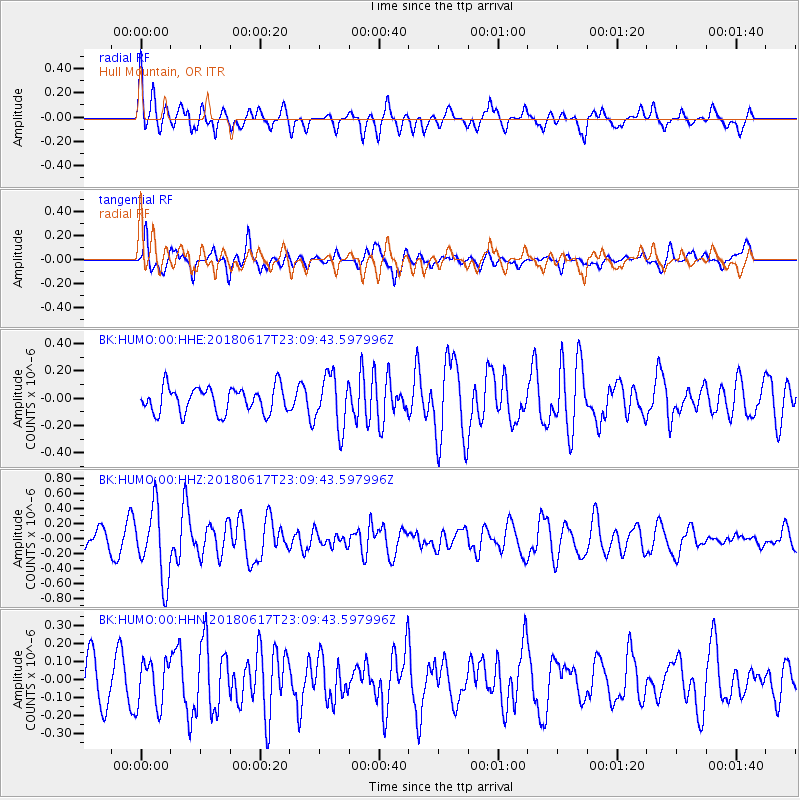
HUMO Hull Mountain, OR - Earthquake Result Viewer
*The percent match for this event was below the threshold and hence no stack was calculated.
| Earthquake location: |
Near S. Coast Of Western Honshu |
| Earthquake latitude/longitude: |
34.8/135.6 |
| Earthquake time(UTC): |
2018/06/17 (168) 22:58:35 GMT |
| Earthquake Depth: |
11 km |
| Earthquake Magnitude: |
5.5 Mww |
| Earthquake Catalog/Contributor: |
NEIC PDE/us |
|
| Network: |
BK Berkeley Digital Seismograph Network |
| Station: |
HUMO Hull Mountain, OR |
| Lat/Lon: |
42.61 N/122.96 W |
| Elevation: |
555 m |
|
| Distance: |
74.7 deg |
| Az: |
48.596 deg |
| Baz: |
303.305 deg |
| Ray Param: |
$rayparam |
*The percent match for this event was below the threshold and hence was not used in the summary stack. |
|
| Radial Match: |
62.777172 % |
| Radial Bump: |
400 |
| Transverse Match: |
59.49575 % |
| Transverse Bump: |
348 |
| SOD ConfigId: |
2709371 |
| Insert Time: |
2018-07-01 22:59:22.624 +0000 |
| GWidth: |
2.5 |
| Max Bumps: |
400 |
| Tol: |
0.001 |
|
Signal To Noise
| Channel | StoN | STA | LTA |
| BK:HUMO:00:HHZ:20180617T23:09:43.597996Z | 4.296388 | 4.852101E-7 | 1.1293442E-7 |
| BK:HUMO:00:HHN:20180617T23:09:43.597996Z | 0.8908905 | 1.2643552E-7 | 1.4192038E-7 |
| BK:HUMO:00:HHE:20180617T23:09:43.597996Z | 2.0376236 | 1.9153862E-7 | 9.400098E-8 |
| Arrivals |
| Ps | |
| PpPs | |
| PsPs/PpSs | |


