You are here: Home > Network List > GM - US Geological Survey Networks Stations List
> Station IWM01 Jericho 2M Well Monitoring Station > Earthquake Result Viewer
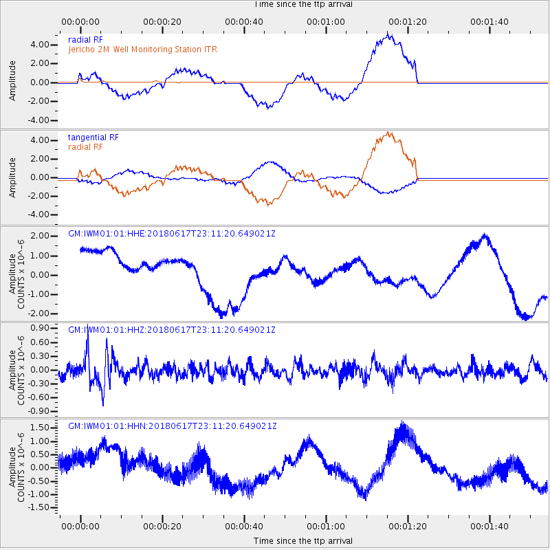
IWM01 Jericho 2M Well Monitoring Station - Earthquake Result Viewer
*The percent match for this event was below the threshold and hence no stack was calculated.
| Earthquake location: |
Near S. Coast Of Western Honshu |
| Earthquake latitude/longitude: |
34.8/135.6 |
| Earthquake time(UTC): |
2018/06/17 (168) 22:58:35 GMT |
| Earthquake Depth: |
11 km |
| Earthquake Magnitude: |
5.5 Mww |
| Earthquake Catalog/Contributor: |
NEIC PDE/us |
|
| Network: |
GM US Geological Survey Networks |
| Station: |
IWM01 Jericho 2M Well Monitoring Station |
| Lat/Lon: |
36.73 N/96.53 W |
| Elevation: |
328 m |
|
| Distance: |
93.8 deg |
| Az: |
39.477 deg |
| Baz: |
319.385 deg |
| Ray Param: |
$rayparam |
*The percent match for this event was below the threshold and hence was not used in the summary stack. |
|
| Radial Match: |
38.206356 % |
| Radial Bump: |
400 |
| Transverse Match: |
32.666344 % |
| Transverse Bump: |
400 |
| SOD ConfigId: |
2709371 |
| Insert Time: |
2018-07-01 22:59:47.872 +0000 |
| GWidth: |
2.5 |
| Max Bumps: |
400 |
| Tol: |
0.001 |
|
Signal To Noise
| Channel | StoN | STA | LTA |
| GM:IWM01:01:HHZ:20180617T23:11:20.649021Z | 1.9892675 | 2.8050442E-7 | 1.410089E-7 |
| GM:IWM01:01:HHN:20180617T23:11:20.649021Z | 2.795681 | 1.0706003E-6 | 3.8294797E-7 |
| GM:IWM01:01:HHE:20180617T23:11:20.649021Z | 5.373807 | 2.1704834E-6 | 4.0390051E-7 |
| Arrivals |
| Ps | |
| PpPs | |
| PsPs/PpSs | |


