You are here: Home > Network List > US - United States National Seismic Network Stations List
> Station AMTX Amarillo, Texas, USA > Earthquake Result Viewer
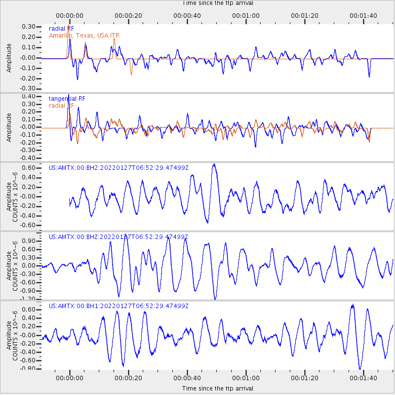
AMTX Amarillo, Texas, USA - Earthquake Result Viewer
*The percent match for this event was below the threshold and hence no stack was calculated.
| Earthquake location: |
Fiji Islands Region |
| Earthquake latitude/longitude: |
-19.1/-176.3 |
| Earthquake time(UTC): |
2022/01/27 (027) 06:40:05 GMT |
| Earthquake Depth: |
4.2 km |
| Earthquake Magnitude: |
6.2 mww |
| Earthquake Catalog/Contributor: |
NEIC PDE/us |
|
| Network: |
US United States National Seismic Network |
| Station: |
AMTX Amarillo, Texas, USA |
| Lat/Lon: |
34.53 N/101.41 W |
| Elevation: |
1010 m |
|
| Distance: |
88.9 deg |
| Az: |
52.883 deg |
| Baz: |
245.994 deg |
| Ray Param: |
$rayparam |
*The percent match for this event was below the threshold and hence was not used in the summary stack. |
|
| Radial Match: |
68.46342 % |
| Radial Bump: |
400 |
| Transverse Match: |
58.48934 % |
| Transverse Bump: |
400 |
| SOD ConfigId: |
26694651 |
| Insert Time: |
2022-02-10 06:57:16.379 +0000 |
| GWidth: |
2.5 |
| Max Bumps: |
400 |
| Tol: |
0.001 |
|
Signal To Noise
| Channel | StoN | STA | LTA |
| US:AMTX:00:BHZ:20220127T06:52:29.47499Z | 0.5595922 | 9.784356E-8 | 1.7484797E-7 |
| US:AMTX:00:BH1:20220127T06:52:29.47499Z | 0.78261036 | 1.2616823E-7 | 1.6121461E-7 |
| US:AMTX:00:BH2:20220127T06:52:29.47499Z | 1.1063364 | 2.0751713E-7 | 1.8757147E-7 |
| Arrivals |
| Ps | |
| PpPs | |
| PsPs/PpSs | |


