You are here: Home > Network List > IU - Global Seismograph Network (GSN - IRIS/USGS) Stations List
> Station RSSD Black Hills, South Dakota, USA > Earthquake Result Viewer
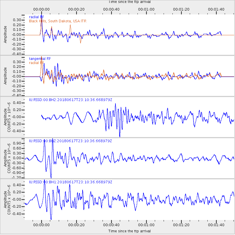
RSSD Black Hills, South Dakota, USA - Earthquake Result Viewer
*The percent match for this event was below the threshold and hence no stack was calculated.
| Earthquake location: |
Near S. Coast Of Western Honshu |
| Earthquake latitude/longitude: |
34.8/135.6 |
| Earthquake time(UTC): |
2018/06/17 (168) 22:58:35 GMT |
| Earthquake Depth: |
11 km |
| Earthquake Magnitude: |
5.5 Mww |
| Earthquake Catalog/Contributor: |
NEIC PDE/us |
|
| Network: |
IU Global Seismograph Network (GSN - IRIS/USGS) |
| Station: |
RSSD Black Hills, South Dakota, USA |
| Lat/Lon: |
44.12 N/104.04 W |
| Elevation: |
2090 m |
|
| Distance: |
84.5 deg |
| Az: |
38.632 deg |
| Baz: |
314.512 deg |
| Ray Param: |
$rayparam |
*The percent match for this event was below the threshold and hence was not used in the summary stack. |
|
| Radial Match: |
58.585682 % |
| Radial Bump: |
376 |
| Transverse Match: |
74.182884 % |
| Transverse Bump: |
400 |
| SOD ConfigId: |
2709371 |
| Insert Time: |
2018-07-01 23:01:04.632 +0000 |
| GWidth: |
2.5 |
| Max Bumps: |
400 |
| Tol: |
0.001 |
|
Signal To Noise
| Channel | StoN | STA | LTA |
| IU:RSSD:00:BHZ:20180617T23:10:36.668979Z | 4.938518 | 4.7429253E-7 | 9.603944E-8 |
| IU:RSSD:00:BH1:20180617T23:10:36.668979Z | 2.602166 | 2.3436485E-7 | 9.00653E-8 |
| IU:RSSD:00:BH2:20180617T23:10:36.668979Z | 1.2554604 | 9.688073E-8 | 7.71675E-8 |
| Arrivals |
| Ps | |
| PpPs | |
| PsPs/PpSs | |


