You are here: Home > Network List > IW - Intermountain West Stations List
> Station PLID Pearl Lake, Idaho, USA > Earthquake Result Viewer
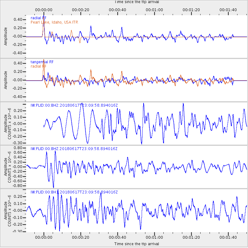
PLID Pearl Lake, Idaho, USA - Earthquake Result Viewer
*The percent match for this event was below the threshold and hence no stack was calculated.
| Earthquake location: |
Near S. Coast Of Western Honshu |
| Earthquake latitude/longitude: |
34.8/135.6 |
| Earthquake time(UTC): |
2018/06/17 (168) 22:58:35 GMT |
| Earthquake Depth: |
11 km |
| Earthquake Magnitude: |
5.5 Mww |
| Earthquake Catalog/Contributor: |
NEIC PDE/us |
|
| Network: |
IW Intermountain West |
| Station: |
PLID Pearl Lake, Idaho, USA |
| Lat/Lon: |
45.09 N/116.00 W |
| Elevation: |
2164 m |
|
| Distance: |
77.4 deg |
| Az: |
43.529 deg |
| Baz: |
306.892 deg |
| Ray Param: |
$rayparam |
*The percent match for this event was below the threshold and hence was not used in the summary stack. |
|
| Radial Match: |
60.31882 % |
| Radial Bump: |
400 |
| Transverse Match: |
46.99217 % |
| Transverse Bump: |
400 |
| SOD ConfigId: |
2709371 |
| Insert Time: |
2018-07-01 23:01:24.561 +0000 |
| GWidth: |
2.5 |
| Max Bumps: |
400 |
| Tol: |
0.001 |
|
Signal To Noise
| Channel | StoN | STA | LTA |
| IW:PLID:00:BHZ:20180617T23:09:58.894016Z | 4.6623783 | 3.2274102E-7 | 6.92224E-8 |
| IW:PLID:00:BH1:20180617T23:09:58.894016Z | 2.4178257 | 1.1399259E-7 | 4.7146738E-8 |
| IW:PLID:00:BH2:20180617T23:09:58.894016Z | 0.85103095 | 1.2839348E-7 | 1.5086816E-7 |
| Arrivals |
| Ps | |
| PpPs | |
| PsPs/PpSs | |


