You are here: Home > Network List > O2 - Oklahoma Consolidated Temporary Seismic Networks Stations List
> Station PW19 Marland, Oklahoma, USA > Earthquake Result Viewer
PW19 Marland, Oklahoma, USA - Earthquake Result Viewer
| Earthquake location: |
Northern Chile |
| Earthquake latitude/longitude: |
-19.1/-69.4 |
| Earthquake time(UTC): |
2022/01/28 (028) 00:31:25 GMT |
| Earthquake Depth: |
96 km |
| Earthquake Magnitude: |
5.5 mww |
| Earthquake Catalog/Contributor: |
NEIC PDE/us |
|
| Network: |
O2 Oklahoma Consolidated Temporary Seismic Networks |
| Station: |
PW19 Marland, Oklahoma, USA |
| Lat/Lon: |
36.57 N/97.04 W |
| Elevation: |
301 m |
|
| Distance: |
61.2 deg |
| Az: |
334.811 deg |
| Baz: |
150.012 deg |
| Ray Param: |
0.06074671 |
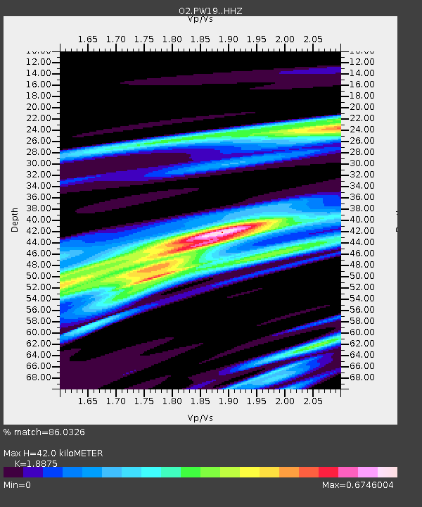
| Estimated Moho Depth: |
42.0 km |
| Estimated Crust Vp/Vs: |
1.89 |
| Assumed Crust Vp: |
6.483 km/s |
| Estimated Crust Vs: |
3.434 km/s |
| Estimated Crust Poisson's Ratio: |
0.30 |
|
| Radial Match: |
86.0326 % |
| Radial Bump: |
255 |
| Transverse Match: |
86.032646 % |
| Transverse Bump: |
255 |
| SOD ConfigId: |
26694651 |
| Insert Time: |
2022-02-11 00:48:28.252 +0000 |
| GWidth: |
2.5 |
| Max Bumps: |
400 |
| Tol: |
0.001 |
|

Signal To Noise
| Channel | StoN | STA | LTA |
| O2:PW19: :HHZ:20220128T00:40:59.49997Z | 4.7042036 | 4.646049E-7 | 9.876378E-8 |
| $trig.getChannelId() | $trig.getValue() | $trig.getSTA() | $trig.getLTA() |
| O2:PW19: :HHE:20220128T00:40:59.49997Z | 5.2039046 | 6.335363E-7 | 1.2174249E-7 |
| Arrivals |
| Ps | 6.0 SECOND |
| PpPs | 18 SECOND |
| PsPs/PpSs | 24 SECOND |


