You are here: Home > Network List > US - United States National Seismic Network Stations List
> Station DGMT Dagmar, Montana, USA > Earthquake Result Viewer
DGMT Dagmar, Montana, USA - Earthquake Result Viewer
*The percent match for this event was below the threshold and hence no stack was calculated.
| Earthquake location: |
Northern Chile |
| Earthquake latitude/longitude: |
-19.1/-69.4 |
| Earthquake time(UTC): |
2022/01/28 (028) 00:31:25 GMT |
| Earthquake Depth: |
96 km |
| Earthquake Magnitude: |
5.5 mww |
| Earthquake Catalog/Contributor: |
NEIC PDE/us |
|
| Network: |
US United States National Seismic Network |
| Station: |
DGMT Dagmar, Montana, USA |
| Lat/Lon: |
48.47 N/104.20 W |
| Elevation: |
0.0 m |
|
| Distance: |
74.1 deg |
| Az: |
336.76 deg |
| Baz: |
145.906 deg |
| Ray Param: |
$rayparam |
*The percent match for this event was below the threshold and hence was not used in the summary stack. |
|
| Radial Match: |
46.850433 % |
| Radial Bump: |
340 |
| Transverse Match: |
65.61351 % |
| Transverse Bump: |
343 |
| SOD ConfigId: |
26694651 |
| Insert Time: |
2022-02-11 00:55:15.419 +0000 |
| GWidth: |
2.5 |
| Max Bumps: |
400 |
| Tol: |
0.001 |
|
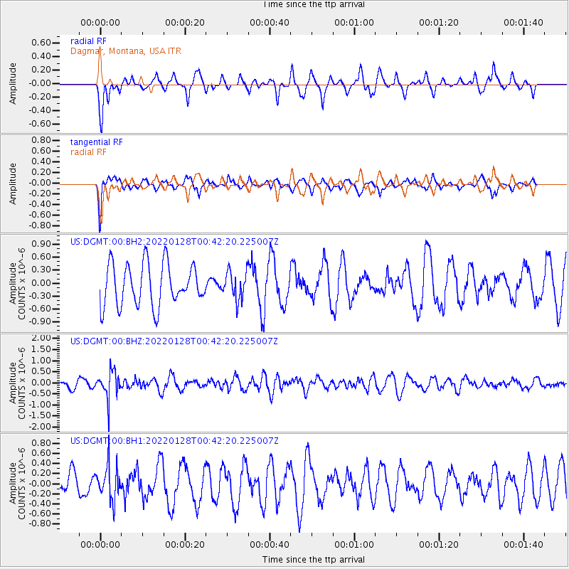
Signal To Noise
| Channel | StoN | STA | LTA |
| US:DGMT:00:BHZ:20220128T00:42:20.225007Z | 2.4524436 | 6.047052E-7 | 2.465725E-7 |
| US:DGMT:00:BH1:20220128T00:42:20.225007Z | 1.025077 | 3.3773702E-7 | 3.2947477E-7 |
| US:DGMT:00:BH2:20220128T00:42:20.225007Z | 0.681521 | 3.2995416E-7 | 4.841438E-7 |
| Arrivals |
| Ps | |
| PpPs | |
| PsPs/PpSs | |


