You are here: Home > Network List > US - United States National Seismic Network Stations List
> Station HAWA Hanford, Washington, USA > Earthquake Result Viewer
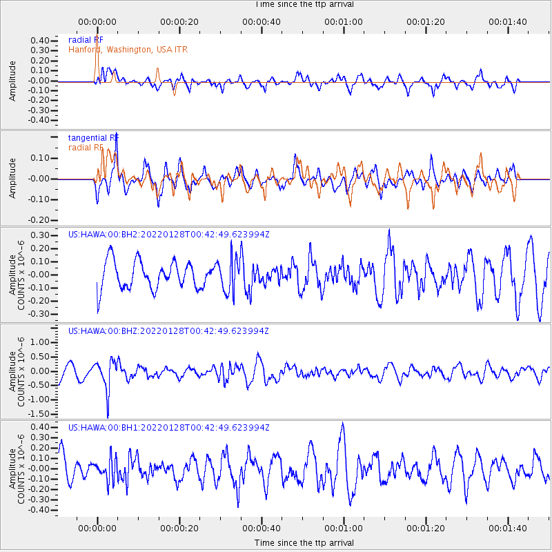
HAWA Hanford, Washington, USA - Earthquake Result Viewer
*The percent match for this event was below the threshold and hence no stack was calculated.
| Earthquake location: |
Northern Chile |
| Earthquake latitude/longitude: |
-19.1/-69.4 |
| Earthquake time(UTC): |
2022/01/28 (028) 00:31:25 GMT |
| Earthquake Depth: |
96 km |
| Earthquake Magnitude: |
5.5 mww |
| Earthquake Catalog/Contributor: |
NEIC PDE/us |
|
| Network: |
US United States National Seismic Network |
| Station: |
HAWA Hanford, Washington, USA |
| Lat/Lon: |
46.39 N/119.53 W |
| Elevation: |
364 m |
|
| Distance: |
79.4 deg |
| Az: |
327.295 deg |
| Baz: |
132.434 deg |
| Ray Param: |
$rayparam |
*The percent match for this event was below the threshold and hence was not used in the summary stack. |
|
| Radial Match: |
59.41925 % |
| Radial Bump: |
400 |
| Transverse Match: |
60.041214 % |
| Transverse Bump: |
400 |
| SOD ConfigId: |
26694651 |
| Insert Time: |
2022-02-11 00:55:26.956 +0000 |
| GWidth: |
2.5 |
| Max Bumps: |
400 |
| Tol: |
0.001 |
|
Signal To Noise
| Channel | StoN | STA | LTA |
| US:HAWA:00:BHZ:20220128T00:42:49.623994Z | 2.3758168 | 5.161498E-7 | 2.1725151E-7 |
| US:HAWA:00:BH1:20220128T00:42:49.623994Z | 0.86621964 | 1.00970674E-7 | 1.1656475E-7 |
| US:HAWA:00:BH2:20220128T00:42:49.623994Z | 1.1872451 | 1.2695311E-7 | 1.0693084E-7 |
| Arrivals |
| Ps | |
| PpPs | |
| PsPs/PpSs | |


