You are here: Home > Network List > US - United States National Seismic Network Stations List
> Station CBKS Cedar Bluff, Kansas, USA > Earthquake Result Viewer
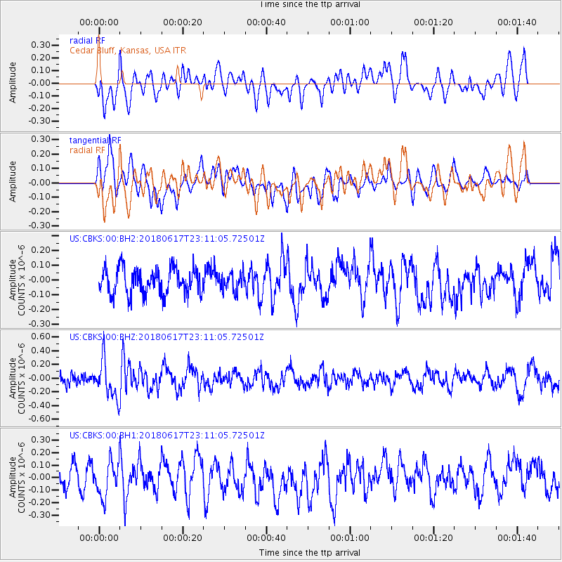
CBKS Cedar Bluff, Kansas, USA - Earthquake Result Viewer
*The percent match for this event was below the threshold and hence no stack was calculated.
| Earthquake location: |
Near S. Coast Of Western Honshu |
| Earthquake latitude/longitude: |
34.8/135.6 |
| Earthquake time(UTC): |
2018/06/17 (168) 22:58:35 GMT |
| Earthquake Depth: |
11 km |
| Earthquake Magnitude: |
5.5 Mww |
| Earthquake Catalog/Contributor: |
NEIC PDE/us |
|
| Network: |
US United States National Seismic Network |
| Station: |
CBKS Cedar Bluff, Kansas, USA |
| Lat/Lon: |
38.81 N/99.74 W |
| Elevation: |
677 m |
|
| Distance: |
90.6 deg |
| Az: |
39.994 deg |
| Baz: |
317.41 deg |
| Ray Param: |
$rayparam |
*The percent match for this event was below the threshold and hence was not used in the summary stack. |
|
| Radial Match: |
55.861465 % |
| Radial Bump: |
400 |
| Transverse Match: |
43.794613 % |
| Transverse Bump: |
400 |
| SOD ConfigId: |
2709371 |
| Insert Time: |
2018-07-01 23:04:10.610 +0000 |
| GWidth: |
2.5 |
| Max Bumps: |
400 |
| Tol: |
0.001 |
|
Signal To Noise
| Channel | StoN | STA | LTA |
| US:CBKS:00:BHZ:20180617T23:11:05.72501Z | 2.6648347 | 2.8266544E-7 | 1.0607241E-7 |
| US:CBKS:00:BH1:20180617T23:11:05.72501Z | 1.690011 | 1.42533E-7 | 8.43385E-8 |
| US:CBKS:00:BH2:20180617T23:11:05.72501Z | 0.7157796 | 6.2675696E-8 | 8.7562846E-8 |
| Arrivals |
| Ps | |
| PpPs | |
| PsPs/PpSs | |


