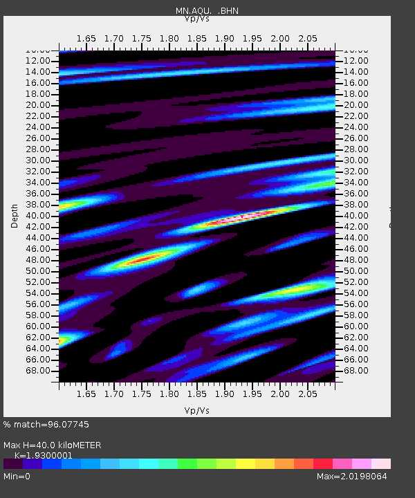
AQU L'Aquila, Italy - Earthquake Result Viewer
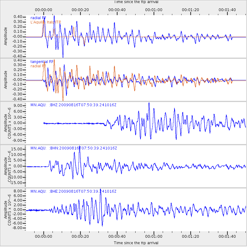
Earthquake location: Southern Sumatra, Indonesia
Earthquake latitude/longitude: -1.5/99.5
Earthquake time(UTC): 2009/08/16 (228) 07:38:21 GMT
Earthquake Depth: 20 km
Earthquake Magnitude: 6.5 MB, 6.7 MS, 6.7 MW, 6.5 MW
Earthquake Catalog/Contributor: WHDF/NEIC
Network: MN MEDNET Project
Station: AQU L'Aquila, Italy
Lat/Lon: 42.35 N/13.40 E
Elevation: 710 m
Distance: 88.1 deg
Az: 312.275 deg
Baz: 93.719 deg
Ray Param: 0.04283038
Estimated Moho Depth: 40.0 km
Estimated Crust Vp/Vs: 1.93
Assumed Crust Vp: 6.276 km/s
Estimated Crust Vs: 3.252 km/s
Estimated Crust Poisson's Ratio: 0.32
Radial Match: 96.07745 %
Radial Bump: 400
Transverse Match: 96.58399 %
Transverse Bump: 400
SOD ConfigId: 2622
Insert Time: 2010-02-26 16:20:19.395 +0000
GWidth: 2.5
Max Bumps: 400
Tol: 0.001

Signal To Noise

ChannelStoNSTALTA
MN:AQU: :BHN:20090816T07:50:39.241016Z31.3941941.9372872E-66.1708455E-8
MN:AQU: :BHE:20090816T07:50:39.241016Z2.24028872.4765833E-71.10547504E-7
MN:AQU: :BHZ:20090816T07:50:39.241016Z6.0190035.804642E-79.6438605E-8
Arrivals
Ps6.0 SECOND
PpPs18 SECOND
PsPs/PpSs24 SECOND