You are here: Home > Network List > MN - MEDNET Project Stations List
> Station AQU L'Aquila, Italy > Earthquake Result Viewer
AQU L'Aquila, Italy - Earthquake Result Viewer
| Earthquake location: |
Myanmar-India Border Region |
| Earthquake latitude/longitude: |
24.3/94.7 |
| Earthquake time(UTC): |
2009/09/03 (246) 19:51:08 GMT |
| Earthquake Depth: |
105 km |
| Earthquake Magnitude: |
5.7 MB, 5.9 MW, 5.8 MW |
| Earthquake Catalog/Contributor: |
WHDF/NEIC |
|
| Network: |
MN MEDNET Project |
| Station: |
AQU L'Aquila, Italy |
| Lat/Lon: |
42.35 N/13.40 E |
| Elevation: |
710 m |
|
| Distance: |
67.8 deg |
| Az: |
307.7 deg |
| Baz: |
76.839 deg |
| Ray Param: |
0.05643862 |
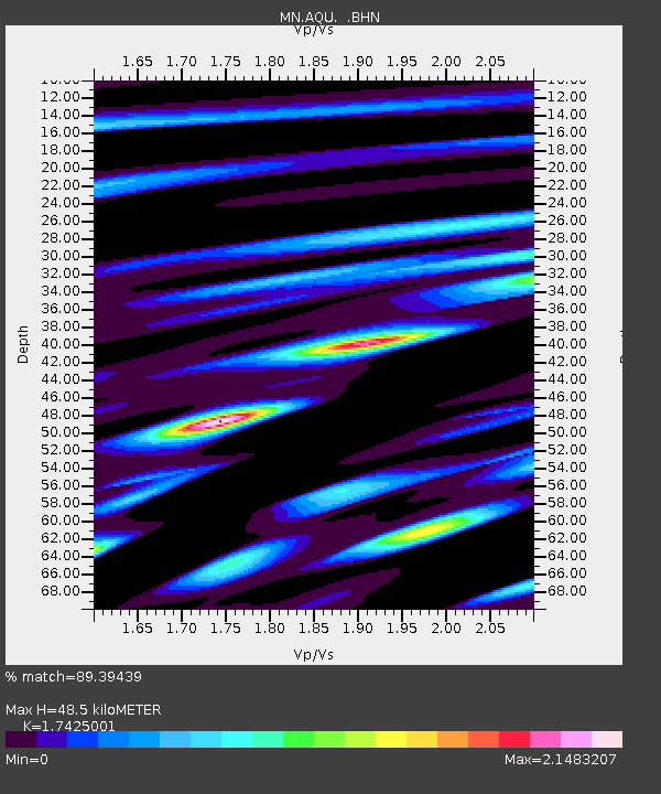
| Estimated Moho Depth: |
48.5 km |
| Estimated Crust Vp/Vs: |
1.74 |
| Assumed Crust Vp: |
6.276 km/s |
| Estimated Crust Vs: |
3.602 km/s |
| Estimated Crust Poisson's Ratio: |
0.25 |
|
| Radial Match: |
89.39439 % |
| Radial Bump: |
400 |
| Transverse Match: |
89.21075 % |
| Transverse Bump: |
400 |
| SOD ConfigId: |
2622 |
| Insert Time: |
2010-02-26 16:20:30.677 +0000 |
| GWidth: |
2.5 |
| Max Bumps: |
400 |
| Tol: |
0.001 |
|

Signal To Noise
| Channel | StoN | STA | LTA |
| MN:AQU: :BHN:20090903T20:01:24.089011Z | 2.950519 | 1.9881838E-7 | 6.738421E-8 |
| MN:AQU: :BHE:20090903T20:01:24.089011Z | 0.98918253 | 1.02266284E-7 | 1.0338464E-7 |
| MN:AQU: :BHZ:20090903T20:01:24.089011Z | 1.1027062 | 1.2039891E-7 | 1.0918493E-7 |
| Arrivals |
| Ps | 6.0 SECOND |
| PpPs | 20 SECOND |
| PsPs/PpSs | 26 SECOND |


