You are here: Home > Network List > AU - Australian Seismological Centre Stations List
> Station WB2 Warramunga Array, Australia > Earthquake Result Viewer
WB2 Warramunga Array, Australia - Earthquake Result Viewer
| Earthquake location: |
Kermadec Islands Region |
| Earthquake latitude/longitude: |
-29.8/-174.7 |
| Earthquake time(UTC): |
2022/01/29 (029) 02:46:28 GMT |
| Earthquake Depth: |
33 km |
| Earthquake Magnitude: |
6.6 Mi |
| Earthquake Catalog/Contributor: |
NEIC PDE/pt |
|
| Network: |
AU Australian Seismological Centre |
| Station: |
WB2 Warramunga Array, Australia |
| Lat/Lon: |
19.94 S/134.35 E |
| Elevation: |
388 m |
|
| Distance: |
46.9 deg |
| Az: |
269.83 deg |
| Baz: |
112.426 deg |
| Ray Param: |
0.07027004 |
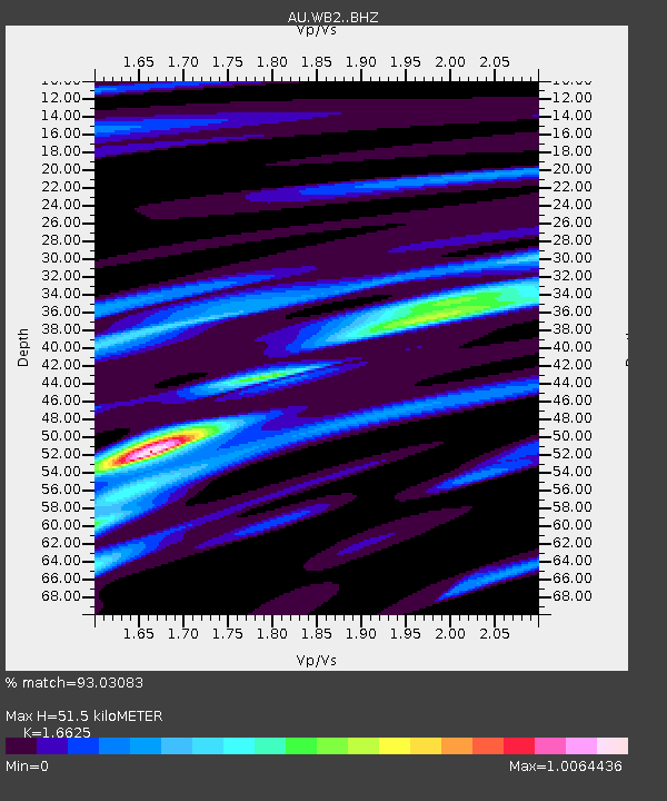
| Estimated Moho Depth: |
51.5 km |
| Estimated Crust Vp/Vs: |
1.66 |
| Assumed Crust Vp: |
6.642 km/s |
| Estimated Crust Vs: |
3.995 km/s |
| Estimated Crust Poisson's Ratio: |
0.22 |
|
| Radial Match: |
93.03083 % |
| Radial Bump: |
335 |
| Transverse Match: |
65.839615 % |
| Transverse Bump: |
400 |
| SOD ConfigId: |
26694651 |
| Insert Time: |
2022-02-12 02:50:05.287 +0000 |
| GWidth: |
2.5 |
| Max Bumps: |
400 |
| Tol: |
0.001 |
|

Signal To Noise
| Channel | StoN | STA | LTA |
| AU:WB2: :BHZ:20220129T02:54:24.875Z | 9.977117 | 1.7137335E-6 | 1.717664E-7 |
| AU:WB2: :BHN:20220129T02:54:24.875Z | 1.0581276 | 2.3317659E-7 | 2.2036717E-7 |
| AU:WB2: :BHE:20220129T02:54:24.875Z | 6.902079 | 9.943465E-7 | 1.4406477E-7 |
| Arrivals |
| Ps | 5.5 SECOND |
| PpPs | 19 SECOND |
| PsPs/PpSs | 25 SECOND |


