You are here: Home > Network List > AU - Australian Seismological Centre Stations List
> Station WB2 Warramunga Array, Australia > Earthquake Result Viewer
WB2 Warramunga Array, Australia - Earthquake Result Viewer
| Earthquake location: |
Kermadec Islands Region |
| Earthquake latitude/longitude: |
-29.5/-176.7 |
| Earthquake time(UTC): |
2022/01/29 (029) 02:46:39 GMT |
| Earthquake Depth: |
10 km |
| Earthquake Magnitude: |
6.4 mww |
| Earthquake Catalog/Contributor: |
NEIC PDE/us |
|
| Network: |
AU Australian Seismological Centre |
| Station: |
WB2 Warramunga Array, Australia |
| Lat/Lon: |
19.94 S/134.35 E |
| Elevation: |
388 m |
|
| Distance: |
45.2 deg |
| Az: |
270.623 deg |
| Baz: |
112.137 deg |
| Ray Param: |
0.07146358 |
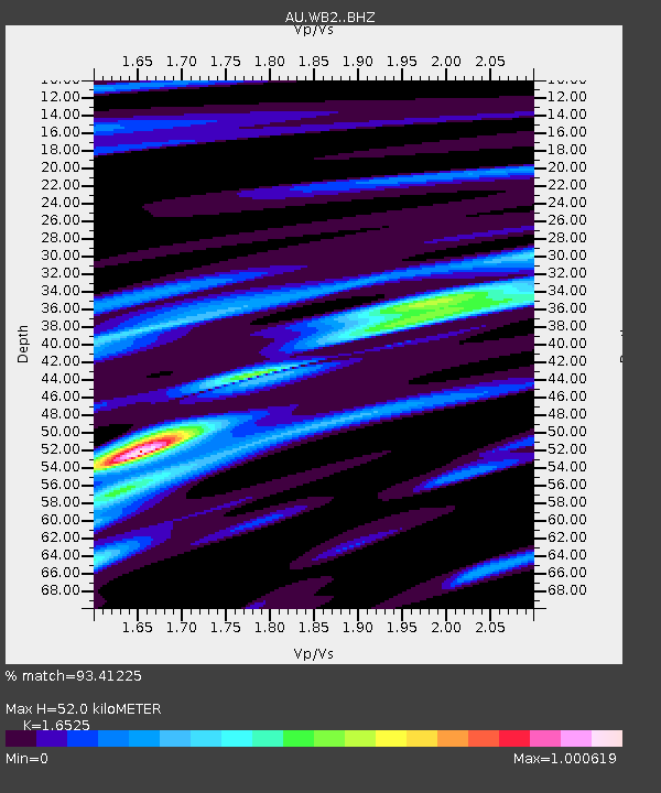
| Estimated Moho Depth: |
52.0 km |
| Estimated Crust Vp/Vs: |
1.65 |
| Assumed Crust Vp: |
6.642 km/s |
| Estimated Crust Vs: |
4.019 km/s |
| Estimated Crust Poisson's Ratio: |
0.21 |
|
| Radial Match: |
93.41225 % |
| Radial Bump: |
317 |
| Transverse Match: |
66.984795 % |
| Transverse Bump: |
400 |
| SOD ConfigId: |
26694651 |
| Insert Time: |
2022-02-12 03:07:29.236 +0000 |
| GWidth: |
2.5 |
| Max Bumps: |
400 |
| Tol: |
0.001 |
|

Signal To Noise
| Channel | StoN | STA | LTA |
| AU:WB2: :BHZ:20220129T02:54:25.649994Z | 11.561108 | 2.0843331E-6 | 1.8028834E-7 |
| AU:WB2: :BHN:20220129T02:54:25.649994Z | 1.1069316 | 2.2932662E-7 | 2.0717326E-7 |
| AU:WB2: :BHE:20220129T02:54:25.649994Z | 7.3391747 | 1.0806303E-6 | 1.472414E-7 |
| Arrivals |
| Ps | 5.5 SECOND |
| PpPs | 19 SECOND |
| PsPs/PpSs | 25 SECOND |


