You are here: Home > Network List > C - Chilean National Seismic Network Stations List
> Station GO06 Curarrehue (Paso Mamuil Malal), Chile > Earthquake Result Viewer
GO06 Curarrehue (Paso Mamuil Malal), Chile - Earthquake Result Viewer
| Earthquake location: |
Kermadec Islands Region |
| Earthquake latitude/longitude: |
-29.5/-176.7 |
| Earthquake time(UTC): |
2022/01/29 (029) 02:46:39 GMT |
| Earthquake Depth: |
10 km |
| Earthquake Magnitude: |
6.4 mww |
| Earthquake Catalog/Contributor: |
NEIC PDE/us |
|
| Network: |
C Chilean National Seismic Network |
| Station: |
GO06 Curarrehue (Paso Mamuil Malal), Chile |
| Lat/Lon: |
39.58 S/71.47 W |
| Elevation: |
1250 m |
|
| Distance: |
82.3 deg |
| Az: |
131.206 deg |
| Baz: |
238.039 deg |
| Ray Param: |
0.04698908 |
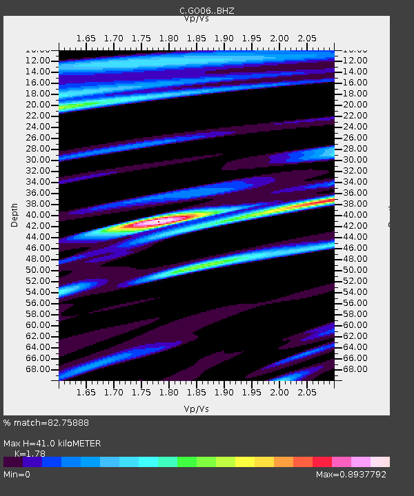
| Estimated Moho Depth: |
41.0 km |
| Estimated Crust Vp/Vs: |
1.78 |
| Assumed Crust Vp: |
6.597 km/s |
| Estimated Crust Vs: |
3.706 km/s |
| Estimated Crust Poisson's Ratio: |
0.27 |
|
| Radial Match: |
82.75888 % |
| Radial Bump: |
400 |
| Transverse Match: |
73.83246 % |
| Transverse Bump: |
400 |
| SOD ConfigId: |
26694651 |
| Insert Time: |
2022-02-12 03:09:50.474 +0000 |
| GWidth: |
2.5 |
| Max Bumps: |
400 |
| Tol: |
0.001 |
|

Signal To Noise
| Channel | StoN | STA | LTA |
| C:GO06: :BHZ:20220129T02:58:29.924988Z | 6.4420986 | 5.753259E-7 | 8.9307214E-8 |
| C:GO06: :BHN:20220129T02:58:29.924988Z | 1.5986544 | 1.7117502E-7 | 1.07074435E-7 |
| C:GO06: :BHE:20220129T02:58:29.924988Z | 1.9627181 | 2.3044402E-7 | 1.1741065E-7 |
| Arrivals |
| Ps | 5.0 SECOND |
| PpPs | 17 SECOND |
| PsPs/PpSs | 22 SECOND |


