You are here: Home > Network List > AU - Australian Seismological Centre Stations List
> Station CMSA Cobar, New South Wales > Earthquake Result Viewer
CMSA Cobar, New South Wales - Earthquake Result Viewer
| Earthquake location: |
Kermadec Islands Region |
| Earthquake latitude/longitude: |
-29.8/-174.7 |
| Earthquake time(UTC): |
2022/01/29 (029) 02:46:49 GMT |
| Earthquake Depth: |
33 km |
| Earthquake Magnitude: |
6.6 Mi |
| Earthquake Catalog/Contributor: |
NEIC PDE/at |
|
| Network: |
AU Australian Seismological Centre |
| Station: |
CMSA Cobar, New South Wales |
| Lat/Lon: |
31.54 S/145.69 E |
| Elevation: |
220 m |
|
| Distance: |
34.0 deg |
| Az: |
256.853 deg |
| Baz: |
97.57 deg |
| Ray Param: |
0.07791027 |
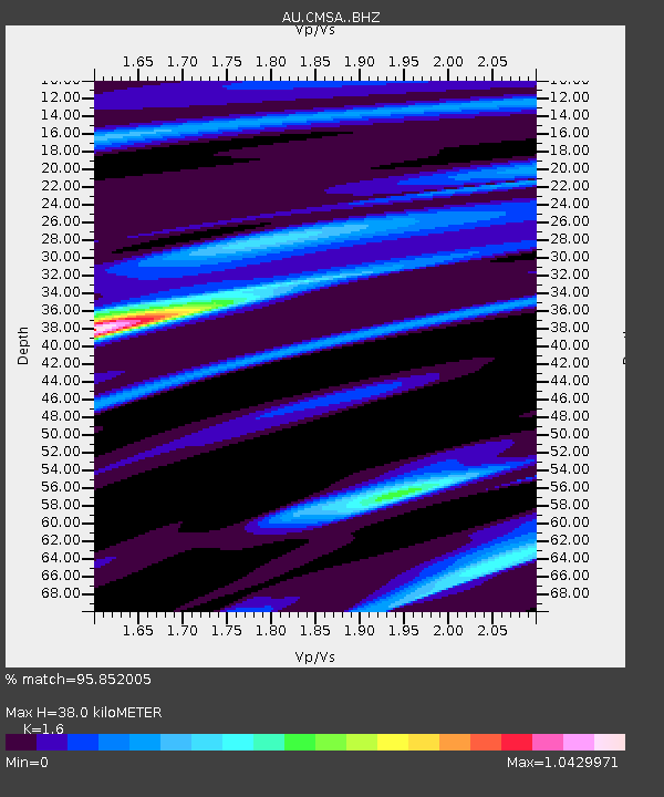
| Estimated Moho Depth: |
38.0 km |
| Estimated Crust Vp/Vs: |
1.60 |
| Assumed Crust Vp: |
6.522 km/s |
| Estimated Crust Vs: |
4.076 km/s |
| Estimated Crust Poisson's Ratio: |
0.18 |
|
| Radial Match: |
95.852005 % |
| Radial Bump: |
391 |
| Transverse Match: |
79.46874 % |
| Transverse Bump: |
400 |
| SOD ConfigId: |
26694651 |
| Insert Time: |
2022-02-12 03:24:41.474 +0000 |
| GWidth: |
2.5 |
| Max Bumps: |
400 |
| Tol: |
0.001 |
|

Signal To Noise
| Channel | StoN | STA | LTA |
| AU:CMSA: :BHZ:20220129T02:52:59.194Z | 0.7887926 | 1.4221553E-6 | 1.802952E-6 |
| AU:CMSA: :BHN:20220129T02:52:59.194Z | 3.1308935 | 7.912364E-7 | 2.5271905E-7 |
| AU:CMSA: :BHE:20220129T02:52:59.194Z | 0.80304664 | 8.4678845E-7 | 1.0544699E-6 |
| Arrivals |
| Ps | 3.8 SECOND |
| PpPs | 14 SECOND |
| PsPs/PpSs | 18 SECOND |


