You are here: Home > Network List > CC - Cascade Chain Volcano Monitoring Stations List
> Station SHRK Shell Rock, OR, USA > Earthquake Result Viewer
SHRK Shell Rock, OR, USA - Earthquake Result Viewer
| Earthquake location: |
Kermadec Islands Region |
| Earthquake latitude/longitude: |
-29.8/-174.7 |
| Earthquake time(UTC): |
2022/01/29 (029) 02:46:49 GMT |
| Earthquake Depth: |
33 km |
| Earthquake Magnitude: |
6.6 Mi |
| Earthquake Catalog/Contributor: |
NEIC PDE/at |
|
| Network: |
CC Cascade Chain Volcano Monitoring |
| Station: |
SHRK Shell Rock, OR, USA |
| Lat/Lon: |
45.46 N/121.53 W |
| Elevation: |
1319 m |
|
| Distance: |
89.1 deg |
| Az: |
34.289 deg |
| Baz: |
224.092 deg |
| Ray Param: |
0.04204751 |
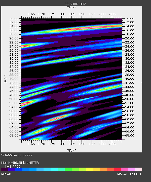
| Estimated Moho Depth: |
59.25 km |
| Estimated Crust Vp/Vs: |
1.77 |
| Assumed Crust Vp: |
6.597 km/s |
| Estimated Crust Vs: |
3.722 km/s |
| Estimated Crust Poisson's Ratio: |
0.27 |
|
| Radial Match: |
81.37292 % |
| Radial Bump: |
400 |
| Transverse Match: |
78.8755 % |
| Transverse Bump: |
400 |
| SOD ConfigId: |
26694651 |
| Insert Time: |
2022-02-12 03:28:30.055 +0000 |
| GWidth: |
2.5 |
| Max Bumps: |
400 |
| Tol: |
0.001 |
|

Signal To Noise
| Channel | StoN | STA | LTA |
| CC:SHRK: :BHZ:20220129T02:59:09.780029Z | 3.4409983 | 4.0786734E-8 | 1.1853169E-8 |
| CC:SHRK: :BHN:20220129T02:59:09.780029Z | 1.206014 | 1.268308E-8 | 1.0516528E-8 |
| CC:SHRK: :BHE:20220129T02:59:09.780029Z | 1.8501815 | 1.6880893E-8 | 9.123911E-9 |
| Arrivals |
| Ps | 7.1 SECOND |
| PpPs | 24 SECOND |
| PsPs/PpSs | 31 SECOND |


