You are here: Home > Network List > GT - Global Telemetered Seismograph Network (USAF/USGS) Stations List
> Station PLCA Paso Flores, Argentina > Earthquake Result Viewer
PLCA Paso Flores, Argentina - Earthquake Result Viewer

| Earthquake location: |
Kermadec Islands Region |
| Earthquake latitude/longitude: |
-29.8/-174.7 |
| Earthquake time(UTC): |
2022/01/29 (029) 02:46:49 GMT |
| Earthquake Depth: |
33 km |
| Earthquake Magnitude: |
6.6 Mi |
| Earthquake Catalog/Contributor: |
NEIC PDE/at |
|
| Network: |
GT Global Telemetered Seismograph Network (USAF/USGS) |
| Station: |
PLCA Paso Flores, Argentina |
| Lat/Lon: |
40.73 S/70.55 W |
| Elevation: |
1080 m |
|
| Distance: |
80.8 deg |
| Az: |
131.714 deg |
| Baz: |
238.63 deg |
| Ray Param: |
0.04799035 |
| Estimated Moho Depth: |
30.0 km |
| Estimated Crust Vp/Vs: |
1.83 |
| Assumed Crust Vp: |
6.597 km/s |
| Estimated Crust Vs: |
3.61 km/s |
| Estimated Crust Poisson's Ratio: |
0.29 |
|
| Radial Match: |
86.03027 % |
| Radial Bump: |
381 |
| Transverse Match: |
59.234745 % |
| Transverse Bump: |
400 |
| SOD ConfigId: |
26694651 |
| Insert Time: |
2022-02-12 03:32:19.362 +0000 |
| GWidth: |
2.5 |
| Max Bumps: |
400 |
| Tol: |
0.001 |
|
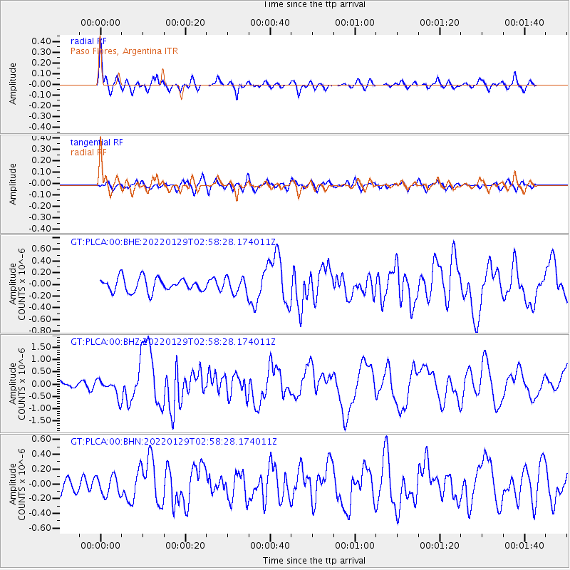
Signal To Noise
| Channel | StoN | STA | LTA |
| GT:PLCA:00:BHZ:20220129T02:58:28.174011Z | 1.838331 | 3.6793614E-7 | 2.0014683E-7 |
| GT:PLCA:00:BHN:20220129T02:58:28.174011Z | 0.9726189 | 1.290233E-7 | 1.3265556E-7 |
| GT:PLCA:00:BHE:20220129T02:58:28.174011Z | 1.1141874 | 1.3014903E-7 | 1.1681072E-7 |
| Arrivals |
| Ps | 3.9 SECOND |
| PpPs | 12 SECOND |
| PsPs/PpSs | 16 SECOND |


