You are here: Home > Network List > XE05 - Sierra Nevada EarthScope Project- EarthScope Flex Array Stations List
> Station SNP57 SNP57 > Earthquake Result Viewer
SNP57 SNP57 - Earthquake Result Viewer
| Earthquake location: |
Rat Islands, Aleutian Islands |
| Earthquake latitude/longitude: |
51.2/179.4 |
| Earthquake time(UTC): |
2005/06/14 (165) 17:10:16 GMT |
| Earthquake Depth: |
51 km |
| Earthquake Magnitude: |
6.0 MB, 6.8 MW, 6.6 MW |
| Earthquake Catalog/Contributor: |
WHDF/NEIC |
|
| Network: |
XE Sierra Nevada EarthScope Project- EarthScope Flex Array |
| Station: |
SNP57 SNP57 |
| Lat/Lon: |
38.14 N/118.97 W |
| Elevation: |
2090 m |
|
| Distance: |
44.4 deg |
| Az: |
82.175 deg |
| Baz: |
307.818 deg |
| Ray Param: |
0.07177567 |
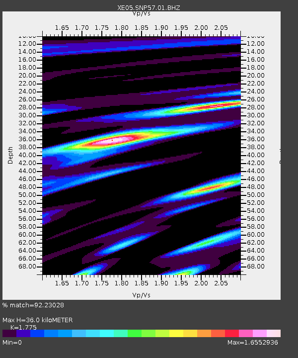
| Estimated Moho Depth: |
36.0 km |
| Estimated Crust Vp/Vs: |
1.77 |
| Assumed Crust Vp: |
6.279 km/s |
| Estimated Crust Vs: |
3.537 km/s |
| Estimated Crust Poisson's Ratio: |
0.27 |
|
| Radial Match: |
92.23028 % |
| Radial Bump: |
400 |
| Transverse Match: |
83.69059 % |
| Transverse Bump: |
400 |
| SOD ConfigId: |
268666 |
| Insert Time: |
2010-03-09 16:21:55.239 +0000 |
| GWidth: |
2.5 |
| Max Bumps: |
400 |
| Tol: |
0.001 |
|

Signal To Noise
| Channel | StoN | STA | LTA |
| XE:SNP57:01:BHZ:20050614T17:17:52.140Z | 20.518156 | 1.7369996E-6 | 8.465671E-8 |
| XE:SNP57:01:BHN:20050614T17:17:52.140Z | 7.146941 | 8.8248606E-7 | 1.2347745E-7 |
| XE:SNP57:01:BHE:20050614T17:17:52.140Z | 7.06586 | 9.038564E-7 | 1.2791881E-7 |
| Arrivals |
| Ps | 4.7 SECOND |
| PpPs | 15 SECOND |
| PsPs/PpSs | 20 SECOND |


