You are here: Home > Network List > GS - US Geological Survey Networks Stations List
> Station KAN13 Rinehart Farm > Earthquake Result Viewer
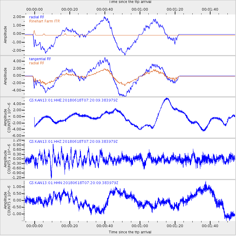
KAN13 Rinehart Farm - Earthquake Result Viewer
*The percent match for this event was below the threshold and hence no stack was calculated.
| Earthquake location: |
Easter Island Region |
| Earthquake latitude/longitude: |
-29.9/-111.9 |
| Earthquake time(UTC): |
2018/06/18 (169) 07:09:41 GMT |
| Earthquake Depth: |
10 km |
| Earthquake Magnitude: |
5.9 Mww |
| Earthquake Catalog/Contributor: |
NEIC PDE/us |
|
| Network: |
GS US Geological Survey Networks |
| Station: |
KAN13 Rinehart Farm |
| Lat/Lon: |
37.01 N/97.48 W |
| Elevation: |
340 m |
|
| Distance: |
67.9 deg |
| Az: |
12.402 deg |
| Baz: |
193.469 deg |
| Ray Param: |
$rayparam |
*The percent match for this event was below the threshold and hence was not used in the summary stack. |
|
| Radial Match: |
39.850574 % |
| Radial Bump: |
400 |
| Transverse Match: |
38.723015 % |
| Transverse Bump: |
400 |
| SOD ConfigId: |
2709371 |
| Insert Time: |
2018-07-02 07:12:20.705 +0000 |
| GWidth: |
2.5 |
| Max Bumps: |
400 |
| Tol: |
0.001 |
|
Signal To Noise
| Channel | StoN | STA | LTA |
| GS:KAN13:01:HHZ:20180618T07:20:09.383979Z | 2.0401235 | 2.6135137E-7 | 1.2810567E-7 |
| GS:KAN13:01:HHN:20180618T07:20:09.383979Z | 0.9797882 | 2.3181973E-7 | 2.3660186E-7 |
| GS:KAN13:01:HHE:20180618T07:20:09.383979Z | 0.61007094 | 6.2164446E-7 | 1.0189708E-6 |
| Arrivals |
| Ps | |
| PpPs | |
| PsPs/PpSs | |


