You are here: Home > Network List > US - United States National Seismic Network Stations List
> Station EGMT Eagleton, Montana, USA > Earthquake Result Viewer
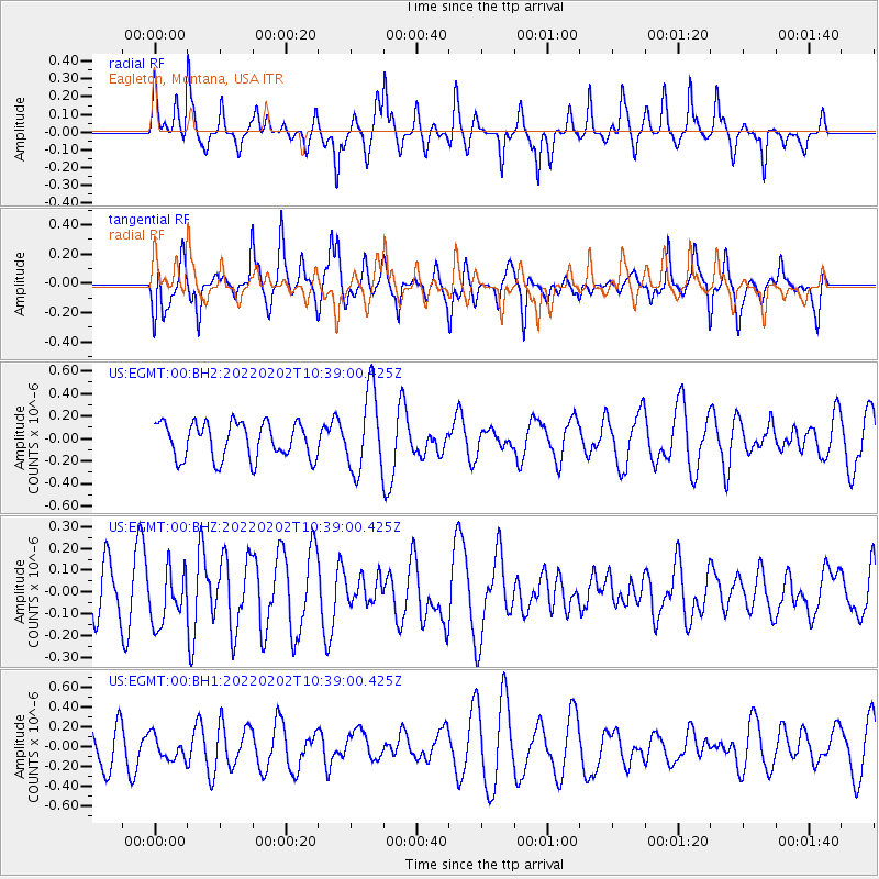
EGMT Eagleton, Montana, USA - Earthquake Result Viewer
*The percent match for this event was below the threshold and hence no stack was calculated.
| Earthquake location: |
Tonga Islands |
| Earthquake latitude/longitude: |
-21.2/-174.3 |
| Earthquake time(UTC): |
2022/02/02 (033) 10:26:33 GMT |
| Earthquake Depth: |
11 km |
| Earthquake Magnitude: |
5.5 mb |
| Earthquake Catalog/Contributor: |
NEIC PDE/us |
|
| Network: |
US United States National Seismic Network |
| Station: |
EGMT Eagleton, Montana, USA |
| Lat/Lon: |
48.02 N/109.75 W |
| Elevation: |
1055 m |
|
| Distance: |
89.8 deg |
| Az: |
37.293 deg |
| Baz: |
237.38 deg |
| Ray Param: |
$rayparam |
*The percent match for this event was below the threshold and hence was not used in the summary stack. |
|
| Radial Match: |
61.82271 % |
| Radial Bump: |
266 |
| Transverse Match: |
61.477406 % |
| Transverse Bump: |
324 |
| SOD ConfigId: |
26694651 |
| Insert Time: |
2022-02-16 10:43:54.233 +0000 |
| GWidth: |
2.5 |
| Max Bumps: |
400 |
| Tol: |
0.001 |
|
Signal To Noise
| Channel | StoN | STA | LTA |
| US:EGMT:00:BHZ:20220202T10:39:00.425Z | 1.1908904 | 1.2302507E-7 | 1.0330512E-7 |
| US:EGMT:00:BH1:20220202T10:39:00.425Z | 0.675696 | 1.2295413E-7 | 1.8196666E-7 |
| US:EGMT:00:BH2:20220202T10:39:00.425Z | 2.2294552 | 3.5373458E-7 | 1.5866412E-7 |
| Arrivals |
| Ps | |
| PpPs | |
| PsPs/PpSs | |


