You are here: Home > Network List > UW - Pacific Northwest Regional Seismic Network Stations List
> Station UMAT Pilot Rock, OR, USA > Earthquake Result Viewer
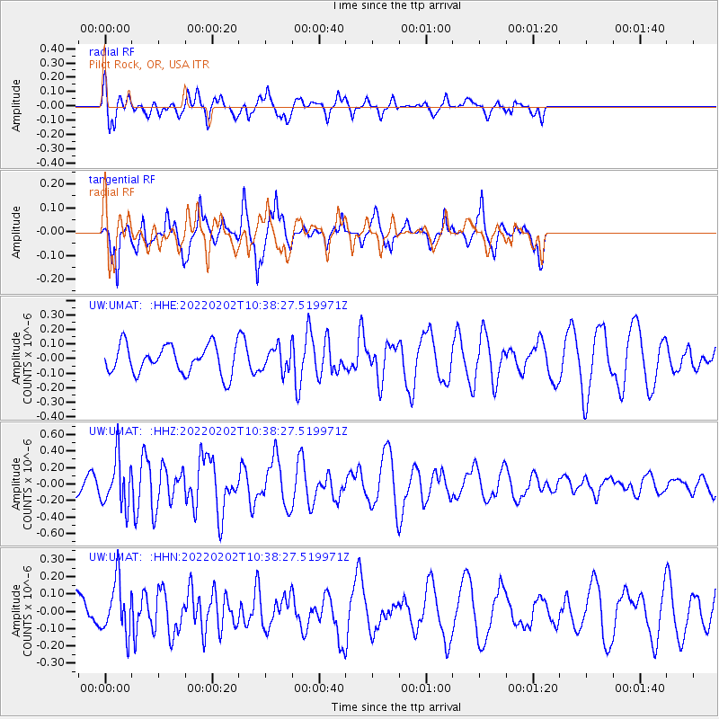
UMAT Pilot Rock, OR, USA - Earthquake Result Viewer
*The percent match for this event was below the threshold and hence no stack was calculated.
| Earthquake location: |
Tonga Islands |
| Earthquake latitude/longitude: |
-21.2/-174.3 |
| Earthquake time(UTC): |
2022/02/02 (033) 10:26:33 GMT |
| Earthquake Depth: |
11 km |
| Earthquake Magnitude: |
5.5 mb |
| Earthquake Catalog/Contributor: |
NEIC PDE/us |
|
| Network: |
UW Pacific Northwest Regional Seismic Network |
| Station: |
UMAT Pilot Rock, OR, USA |
| Lat/Lon: |
45.29 N/118.96 W |
| Elevation: |
1318 m |
|
| Distance: |
83.1 deg |
| Az: |
35.772 deg |
| Baz: |
230.604 deg |
| Ray Param: |
$rayparam |
*The percent match for this event was below the threshold and hence was not used in the summary stack. |
|
| Radial Match: |
72.99017 % |
| Radial Bump: |
376 |
| Transverse Match: |
64.5809 % |
| Transverse Bump: |
347 |
| SOD ConfigId: |
26694651 |
| Insert Time: |
2022-02-16 10:45:08.189 +0000 |
| GWidth: |
2.5 |
| Max Bumps: |
400 |
| Tol: |
0.001 |
|
Signal To Noise
| Channel | StoN | STA | LTA |
| UW:UMAT: :HHZ:20220202T10:38:27.519971Z | 2.7058275 | 2.9053908E-7 | 1.07375314E-7 |
| UW:UMAT: :HHN:20220202T10:38:27.519971Z | 2.3724935 | 1.524059E-7 | 6.4238705E-8 |
| UW:UMAT: :HHE:20220202T10:38:27.519971Z | 0.8218033 | 8.0082266E-8 | 9.7447E-8 |
| Arrivals |
| Ps | |
| PpPs | |
| PsPs/PpSs | |


