You are here: Home > Network List > 1E - GSC-BCOGC Induced Seismicity Study Stations List
> Station MONT4 Z > Earthquake Result Viewer
MONT4 Z - Earthquake Result Viewer
| Earthquake location: |
Northern Peru |
| Earthquake latitude/longitude: |
-4.5/-76.9 |
| Earthquake time(UTC): |
2022/02/03 (034) 15:58:56 GMT |
| Earthquake Depth: |
100 km |
| Earthquake Magnitude: |
6.5 mww |
| Earthquake Catalog/Contributor: |
NEIC PDE/us |
|
| Network: |
1E GSC-BCOGC Induced Seismicity Study |
| Station: |
MONT4 Z |
| Lat/Lon: |
57.32 N/122.71 W |
| Elevation: |
1110 m |
|
| Distance: |
71.8 deg |
| Az: |
335.844 deg |
| Baz: |
131.233 deg |
| Ray Param: |
0.053853605 |
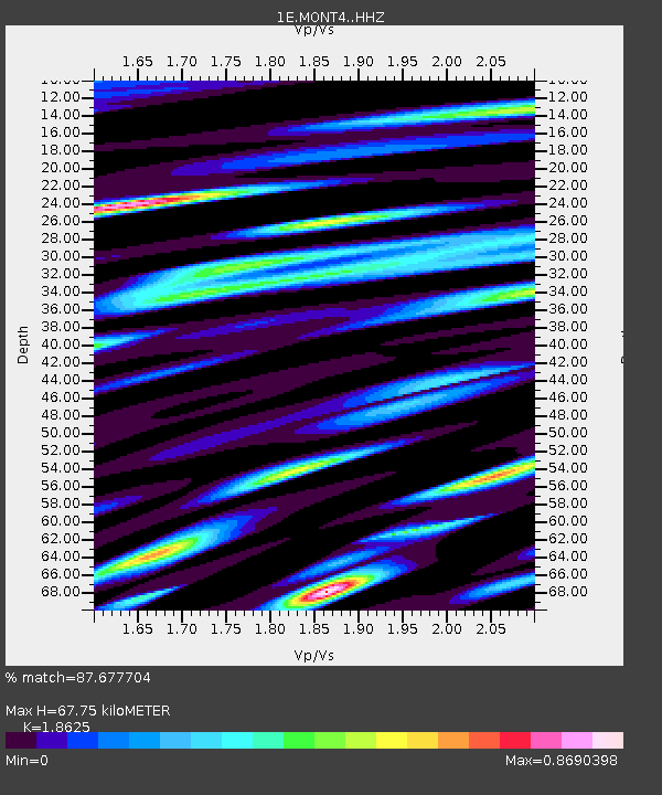
| Estimated Moho Depth: |
67.75 km |
| Estimated Crust Vp/Vs: |
1.86 |
| Assumed Crust Vp: |
6.232 km/s |
| Estimated Crust Vs: |
3.346 km/s |
| Estimated Crust Poisson's Ratio: |
0.30 |
|
| Radial Match: |
87.677704 % |
| Radial Bump: |
400 |
| Transverse Match: |
74.5905 % |
| Transverse Bump: |
400 |
| SOD ConfigId: |
26694651 |
| Insert Time: |
2022-02-17 15:59:43.276 +0000 |
| GWidth: |
2.5 |
| Max Bumps: |
400 |
| Tol: |
0.001 |
|

Signal To Noise
| Channel | StoN | STA | LTA |
| 1E:MONT4: :HHZ:20220203T16:09:37.340009Z | 17.427736 | 4.99552E-6 | 2.8664195E-7 |
| 1E:MONT4: :HHN:20220203T16:09:37.340009Z | 4.506744 | 1.1657038E-6 | 2.5865765E-7 |
| 1E:MONT4: :HHE:20220203T16:09:37.340009Z | 7.4968805 | 1.8326126E-6 | 2.4445E-7 |
| Arrivals |
| Ps | 9.7 SECOND |
| PpPs | 30 SECOND |
| PsPs/PpSs | 40 SECOND |


