You are here: Home > Network List > AG - Arkansas Seismic Network Stations List
> Station XB02 XB02 > Earthquake Result Viewer
XB02 XB02 - Earthquake Result Viewer

| Earthquake location: |
Northern Peru |
| Earthquake latitude/longitude: |
-4.5/-76.9 |
| Earthquake time(UTC): |
2022/02/03 (034) 15:58:56 GMT |
| Earthquake Depth: |
100 km |
| Earthquake Magnitude: |
6.5 mww |
| Earthquake Catalog/Contributor: |
NEIC PDE/us |
|
| Network: |
AG Arkansas Seismic Network |
| Station: |
XB02 XB02 |
| Lat/Lon: |
33.20 N/92.49 W |
| Elevation: |
69 m |
|
| Distance: |
40.2 deg |
| Az: |
339.638 deg |
| Baz: |
155.559 deg |
| Ray Param: |
0.074180275 |
| Estimated Moho Depth: |
14.75 km |
| Estimated Crust Vp/Vs: |
1.63 |
| Assumed Crust Vp: |
6.245 km/s |
| Estimated Crust Vs: |
3.82 km/s |
| Estimated Crust Poisson's Ratio: |
0.20 |
|
| Radial Match: |
83.84144 % |
| Radial Bump: |
400 |
| Transverse Match: |
57.63065 % |
| Transverse Bump: |
400 |
| SOD ConfigId: |
26694651 |
| Insert Time: |
2022-02-17 16:00:54.033 +0000 |
| GWidth: |
2.5 |
| Max Bumps: |
400 |
| Tol: |
0.001 |
|
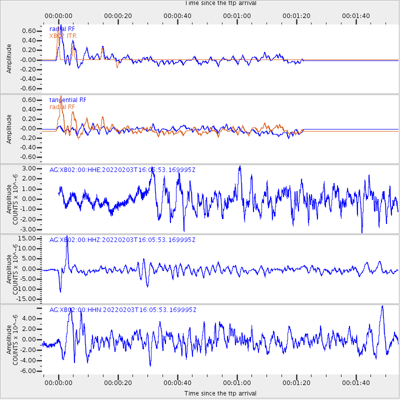
Signal To Noise
| Channel | StoN | STA | LTA |
| AG:XB02:00:HHZ:20220203T16:05:53.169995Z | 20.940802 | 5.6140475E-6 | 2.6809133E-7 |
| AG:XB02:00:HHN:20220203T16:05:53.169995Z | 4.0586367 | 2.9880678E-6 | 7.362245E-7 |
| AG:XB02:00:HHE:20220203T16:05:53.169995Z | 3.209308 | 1.6972825E-6 | 5.288625E-7 |
| Arrivals |
| Ps | 1.6 SECOND |
| PpPs | 5.8 SECOND |
| PsPs/PpSs | 7.4 SECOND |


