You are here: Home > Network List > CM - Red Sismologica Nacional de Columbia Stations List
> Station PRV Islas San Andres y Providencia, Colombia > Earthquake Result Viewer
PRV Islas San Andres y Providencia, Colombia - Earthquake Result Viewer
| Earthquake location: |
Chile-Argentina Border Region |
| Earthquake latitude/longitude: |
-24.3/-67.1 |
| Earthquake time(UTC): |
2018/06/21 (172) 16:08:02 GMT |
| Earthquake Depth: |
175 km |
| Earthquake Magnitude: |
5.7 Mww |
| Earthquake Catalog/Contributor: |
NEIC PDE/us |
|
| Network: |
CM Red Sismologica Nacional de Columbia |
| Station: |
PRV Islas San Andres y Providencia, Colombia |
| Lat/Lon: |
13.38 N/81.36 W |
| Elevation: |
205 m |
|
| Distance: |
40.0 deg |
| Az: |
338.033 deg |
| Baz: |
159.472 deg |
| Ray Param: |
0.074016474 |
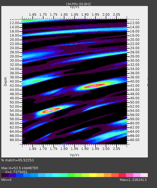
| Estimated Moho Depth: |
53.5 km |
| Estimated Crust Vp/Vs: |
1.74 |
| Assumed Crust Vp: |
6.048 km/s |
| Estimated Crust Vs: |
3.481 km/s |
| Estimated Crust Poisson's Ratio: |
0.25 |
|
| Radial Match: |
85.52253 % |
| Radial Bump: |
400 |
| Transverse Match: |
79.6332 % |
| Transverse Bump: |
400 |
| SOD ConfigId: |
2709371 |
| Insert Time: |
2018-07-05 16:09:38.526 +0000 |
| GWidth: |
2.5 |
| Max Bumps: |
400 |
| Tol: |
0.001 |
|

Signal To Noise
| Channel | StoN | STA | LTA |
| CM:PRV:00:BHZ:20180621T16:14:49.119Z | 22.62028 | 6.1106954E-7 | 2.7014236E-8 |
| CM:PRV:00:BHN:20180621T16:14:49.119Z | 9.557879 | 2.8297706E-7 | 2.9606678E-8 |
| CM:PRV:00:BHE:20180621T16:14:49.119Z | 5.6331067 | 1.7096667E-7 | 3.0350336E-8 |
| Arrivals |
| Ps | 6.9 SECOND |
| PpPs | 23 SECOND |
| PsPs/PpSs | 30 SECOND |


