You are here: Home > Network List > C - Chilean National Seismic Network Stations List
> Station GO06 Curarrehue (Paso Mamuil Malal), Chile > Earthquake Result Viewer
GO06 Curarrehue (Paso Mamuil Malal), Chile - Earthquake Result Viewer
| Earthquake location: |
Northern Peru |
| Earthquake latitude/longitude: |
-4.5/-76.9 |
| Earthquake time(UTC): |
2022/02/03 (034) 15:58:56 GMT |
| Earthquake Depth: |
100 km |
| Earthquake Magnitude: |
6.5 mww |
| Earthquake Catalog/Contributor: |
NEIC PDE/us |
|
| Network: |
C Chilean National Seismic Network |
| Station: |
GO06 Curarrehue (Paso Mamuil Malal), Chile |
| Lat/Lon: |
39.58 S/71.47 W |
| Elevation: |
1250 m |
|
| Distance: |
35.3 deg |
| Az: |
172.683 deg |
| Baz: |
350.542 deg |
| Ray Param: |
0.07698096 |
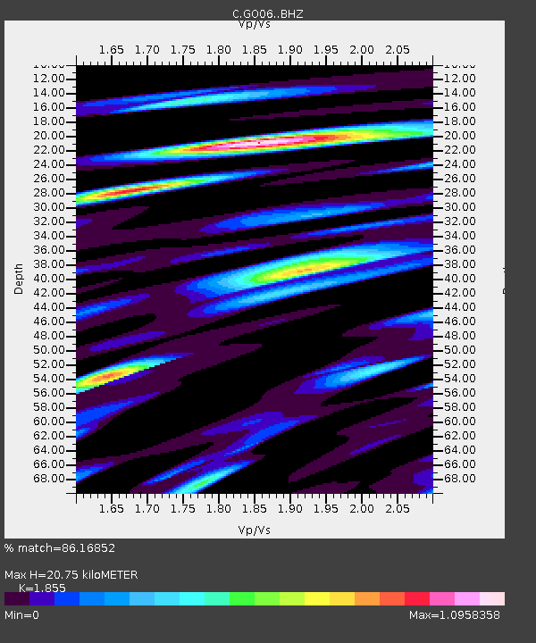
| Estimated Moho Depth: |
20.75 km |
| Estimated Crust Vp/Vs: |
1.86 |
| Assumed Crust Vp: |
6.597 km/s |
| Estimated Crust Vs: |
3.557 km/s |
| Estimated Crust Poisson's Ratio: |
0.30 |
|
| Radial Match: |
86.16852 % |
| Radial Bump: |
400 |
| Transverse Match: |
74.183624 % |
| Transverse Bump: |
400 |
| SOD ConfigId: |
26694651 |
| Insert Time: |
2022-02-17 16:07:59.511 +0000 |
| GWidth: |
2.5 |
| Max Bumps: |
400 |
| Tol: |
0.001 |
|

Signal To Noise
| Channel | StoN | STA | LTA |
| C:GO06: :BHZ:20220203T16:05:11.798993Z | 15.8332615 | 3.7329144E-6 | 2.3576409E-7 |
| C:GO06: :BHN:20220203T16:05:11.798993Z | 9.28329 | 2.6026778E-6 | 2.8036158E-7 |
| C:GO06: :BHE:20220203T16:05:11.798993Z | 4.068732 | 1.1677329E-6 | 2.8700168E-7 |
| Arrivals |
| Ps | 2.9 SECOND |
| PpPs | 8.3 SECOND |
| PsPs/PpSs | 11 SECOND |


