You are here: Home > Network List > G - GEOSCOPE Stations List
> Station MPG Montagne des Peres, French Guyana > Earthquake Result Viewer
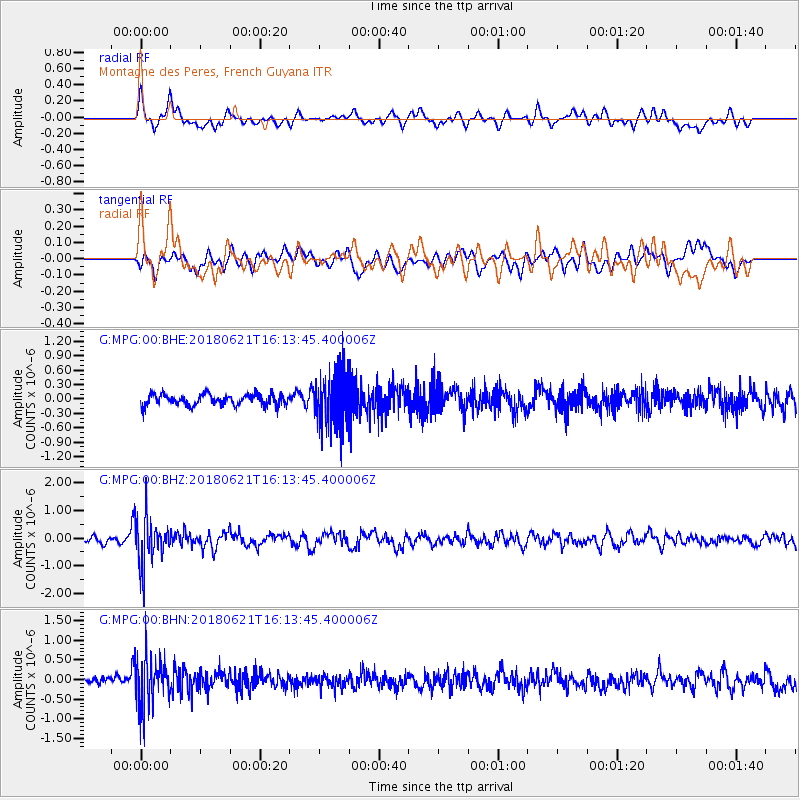
MPG Montagne des Peres, French Guyana - Earthquake Result Viewer
*The percent match for this event was below the threshold and hence no stack was calculated.
| Earthquake location: |
Chile-Argentina Border Region |
| Earthquake latitude/longitude: |
-24.3/-67.1 |
| Earthquake time(UTC): |
2018/06/21 (172) 16:08:02 GMT |
| Earthquake Depth: |
175 km |
| Earthquake Magnitude: |
5.7 Mww |
| Earthquake Catalog/Contributor: |
NEIC PDE/us |
|
| Network: |
G GEOSCOPE |
| Station: |
MPG Montagne des Peres, French Guyana |
| Lat/Lon: |
5.11 N/52.64 W |
| Elevation: |
147 m |
|
| Distance: |
32.4 deg |
| Az: |
27.538 deg |
| Baz: |
205.053 deg |
| Ray Param: |
$rayparam |
*The percent match for this event was below the threshold and hence was not used in the summary stack. |
|
| Radial Match: |
67.22459 % |
| Radial Bump: |
400 |
| Transverse Match: |
52.21578 % |
| Transverse Bump: |
400 |
| SOD ConfigId: |
2709371 |
| Insert Time: |
2018-07-05 16:11:04.160 +0000 |
| GWidth: |
2.5 |
| Max Bumps: |
400 |
| Tol: |
0.001 |
|
Signal To Noise
| Channel | StoN | STA | LTA |
| G:MPG:00:BHZ:20180621T16:13:45.400006Z | 7.3079844 | 8.210037E-7 | 1.12343386E-7 |
| G:MPG:00:BHN:20180621T16:13:45.400006Z | 5.5206966 | 6.370973E-7 | 1.1540161E-7 |
| G:MPG:00:BHE:20180621T16:13:45.400006Z | 4.8317285 | 5.650318E-7 | 1.16941955E-7 |
| Arrivals |
| Ps | |
| PpPs | |
| PsPs/PpSs | |


