You are here: Home > Network List > GM - US Geological Survey Networks Stations List
> Station IWM01 Jericho 2M Well Monitoring Station > Earthquake Result Viewer
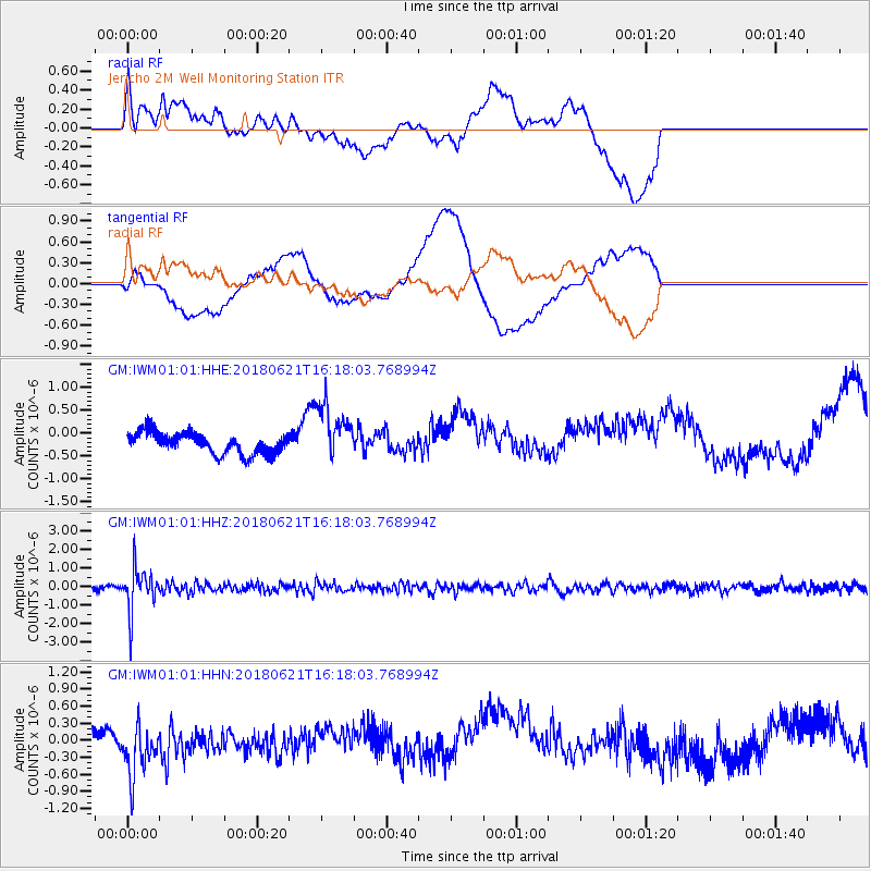
IWM01 Jericho 2M Well Monitoring Station - Earthquake Result Viewer
*The percent match for this event was below the threshold and hence no stack was calculated.
| Earthquake location: |
Chile-Argentina Border Region |
| Earthquake latitude/longitude: |
-24.3/-67.1 |
| Earthquake time(UTC): |
2018/06/21 (172) 16:08:02 GMT |
| Earthquake Depth: |
175 km |
| Earthquake Magnitude: |
5.7 Mww |
| Earthquake Catalog/Contributor: |
NEIC PDE/us |
|
| Network: |
GM US Geological Survey Networks |
| Station: |
IWM01 Jericho 2M Well Monitoring Station |
| Lat/Lon: |
36.73 N/96.53 W |
| Elevation: |
328 m |
|
| Distance: |
66.8 deg |
| Az: |
334.528 deg |
| Baz: |
150.767 deg |
| Ray Param: |
$rayparam |
*The percent match for this event was below the threshold and hence was not used in the summary stack. |
|
| Radial Match: |
32.21238 % |
| Radial Bump: |
400 |
| Transverse Match: |
56.400543 % |
| Transverse Bump: |
400 |
| SOD ConfigId: |
2709371 |
| Insert Time: |
2018-07-05 16:11:27.482 +0000 |
| GWidth: |
2.5 |
| Max Bumps: |
400 |
| Tol: |
0.001 |
|
Signal To Noise
| Channel | StoN | STA | LTA |
| GM:IWM01:01:HHZ:20180621T16:18:03.768994Z | 9.558186 | 1.1641752E-6 | 1.2179875E-7 |
| GM:IWM01:01:HHN:20180621T16:18:03.768994Z | 2.3738956 | 4.5137443E-7 | 1.9014081E-7 |
| GM:IWM01:01:HHE:20180621T16:18:03.768994Z | 2.6459367 | 6.1270845E-7 | 2.315658E-7 |
| Arrivals |
| Ps | |
| PpPs | |
| PsPs/PpSs | |


