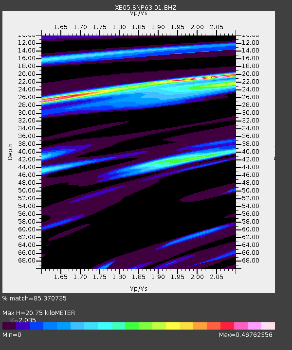
SNP63 SNP63 - Earthquake Result Viewer

Earthquake location: Kuril Islands
Earthquake latitude/longitude: 46.3/153.3
Earthquake time(UTC): 2006/10/13 (286) 13:47:39 GMT
Earthquake Depth: 8.0 km
Earthquake Magnitude: 5.5 MB, 5.8 MS, 6.3 MW, 5.8 MW
Earthquake Catalog/Contributor: WHDF/NEIC
Network: XE Sierra Nevada EarthScope Project- EarthScope Flex Array
Station: SNP63 SNP63
Lat/Lon: 37.72 N/119.81 W
Elevation: 1906 m
Distance: 62.1 deg
Az: 63.659 deg
Baz: 308.351 deg
Ray Param: 0.060471766
Estimated Moho Depth: 20.75 km
Estimated Crust Vp/Vs: 2.04
Assumed Crust Vp: 6.291 km/s
Estimated Crust Vs: 3.092 km/s
Estimated Crust Poisson's Ratio: 0.34
Radial Match: 85.370735 %
Radial Bump: 375
Transverse Match: 69.55123 %
Transverse Bump: 400
SOD ConfigId: 268666
Insert Time: 2010-03-09 16:29:03.851 +0000
GWidth: 2.5
Max Bumps: 400
Tol: 0.001

Signal To Noise

ChannelStoNSTALTA
XE:SNP63:01:BHZ:20061013T13:57:29.814011Z3.57463624.7393178E-71.3258182E-7
XE:SNP63:01:BHN:20061013T13:57:29.814011Z1.34683042.419608E-71.7965205E-7
XE:SNP63:01:BHE:20061013T13:57:29.814011Z2.9637231.909347E-76.4423936E-8
Arrivals
Ps3.5 SECOND
PpPs9.6 SECOND
PsPs/PpSs13 SECOND