You are here: Home > Network List > GS - US Geological Survey Networks Stations List
> Station ASL8 Albuquerque, New Mexico, USA > Earthquake Result Viewer
ASL8 Albuquerque, New Mexico, USA - Earthquake Result Viewer
| Earthquake location: |
Chile-Argentina Border Region |
| Earthquake latitude/longitude: |
-24.3/-67.1 |
| Earthquake time(UTC): |
2018/06/21 (172) 16:08:02 GMT |
| Earthquake Depth: |
175 km |
| Earthquake Magnitude: |
5.7 Mww |
| Earthquake Catalog/Contributor: |
NEIC PDE/us |
|
| Network: |
GS US Geological Survey Networks |
| Station: |
ASL8 Albuquerque, New Mexico, USA |
| Lat/Lon: |
34.95 N/106.46 W |
| Elevation: |
1820 m |
|
| Distance: |
69.8 deg |
| Az: |
326.248 deg |
| Baz: |
141.901 deg |
| Ray Param: |
0.05493869 |
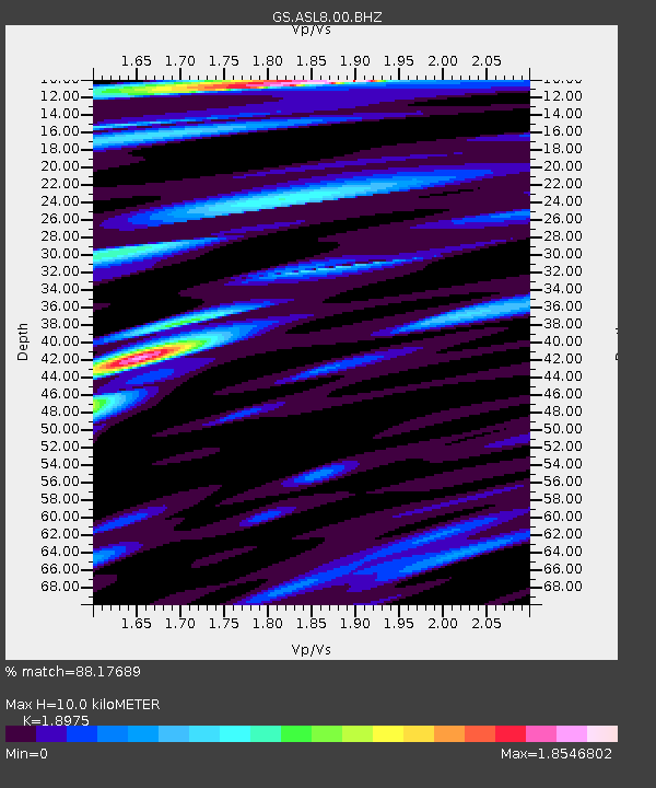
| Estimated Moho Depth: |
10.0 km |
| Estimated Crust Vp/Vs: |
1.90 |
| Assumed Crust Vp: |
6.502 km/s |
| Estimated Crust Vs: |
3.426 km/s |
| Estimated Crust Poisson's Ratio: |
0.31 |
|
| Radial Match: |
88.17689 % |
| Radial Bump: |
400 |
| Transverse Match: |
61.563004 % |
| Transverse Bump: |
400 |
| SOD ConfigId: |
2709371 |
| Insert Time: |
2018-07-05 16:11:29.090 +0000 |
| GWidth: |
2.5 |
| Max Bumps: |
400 |
| Tol: |
0.001 |
|
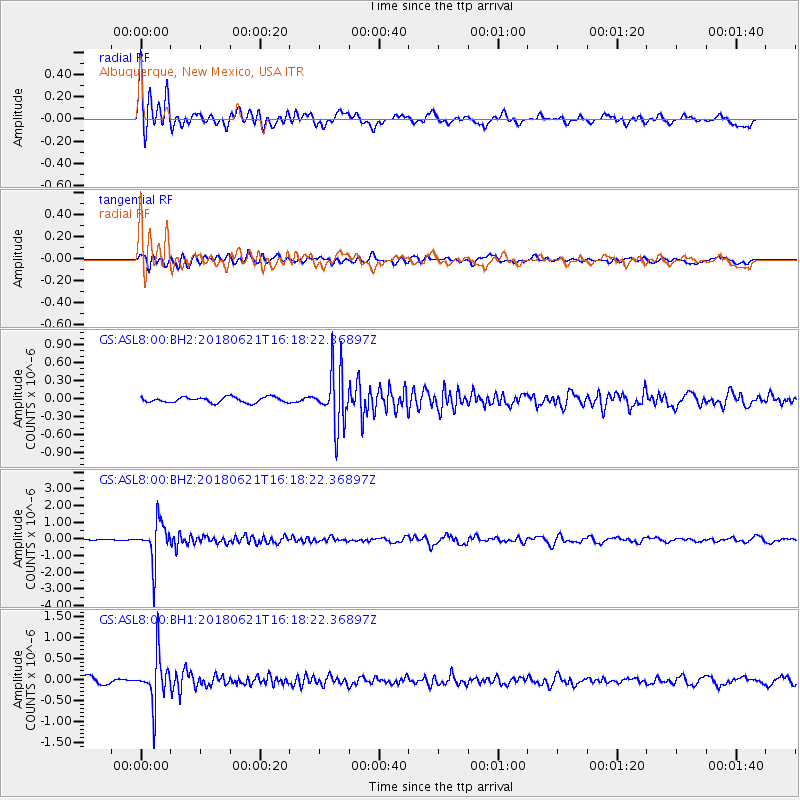
Signal To Noise
| Channel | StoN | STA | LTA |
| GS:ASL8:00:BHZ:20180621T16:18:22.36897Z | 29.813221 | 1.1934345E-6 | 4.003038E-8 |
| GS:ASL8:00:BH1:20180621T16:18:22.36897Z | 8.171477 | 5.6617944E-7 | 6.928728E-8 |
| GS:ASL8:00:BH2:20180621T16:18:22.36897Z | 10.0977125 | 4.5688074E-7 | 4.5245965E-8 |
| Arrivals |
| Ps | 1.4 SECOND |
| PpPs | 4.3 SECOND |
| PsPs/PpSs | 5.7 SECOND |


