You are here: Home > Network List > CN - Canadian National Seismograph Network Stations List
> Station ULM LAC DU BONNET, MB > Earthquake Result Viewer
ULM LAC DU BONNET, MB - Earthquake Result Viewer

| Earthquake location: |
Northern Peru |
| Earthquake latitude/longitude: |
-4.5/-76.9 |
| Earthquake time(UTC): |
2022/02/03 (034) 15:58:56 GMT |
| Earthquake Depth: |
100 km |
| Earthquake Magnitude: |
6.5 mww |
| Earthquake Catalog/Contributor: |
NEIC PDE/us |
|
| Network: |
CN Canadian National Seismograph Network |
| Station: |
ULM LAC DU BONNET, MB |
| Lat/Lon: |
50.25 N/95.88 W |
| Elevation: |
251 m |
|
| Distance: |
56.9 deg |
| Az: |
345.599 deg |
| Baz: |
157.278 deg |
| Ray Param: |
0.06355766 |
| Estimated Moho Depth: |
34.25 km |
| Estimated Crust Vp/Vs: |
1.74 |
| Assumed Crust Vp: |
6.459 km/s |
| Estimated Crust Vs: |
3.707 km/s |
| Estimated Crust Poisson's Ratio: |
0.25 |
|
| Radial Match: |
93.272354 % |
| Radial Bump: |
257 |
| Transverse Match: |
70.78077 % |
| Transverse Bump: |
400 |
| SOD ConfigId: |
26694651 |
| Insert Time: |
2022-02-17 16:15:52.587 +0000 |
| GWidth: |
2.5 |
| Max Bumps: |
400 |
| Tol: |
0.001 |
|
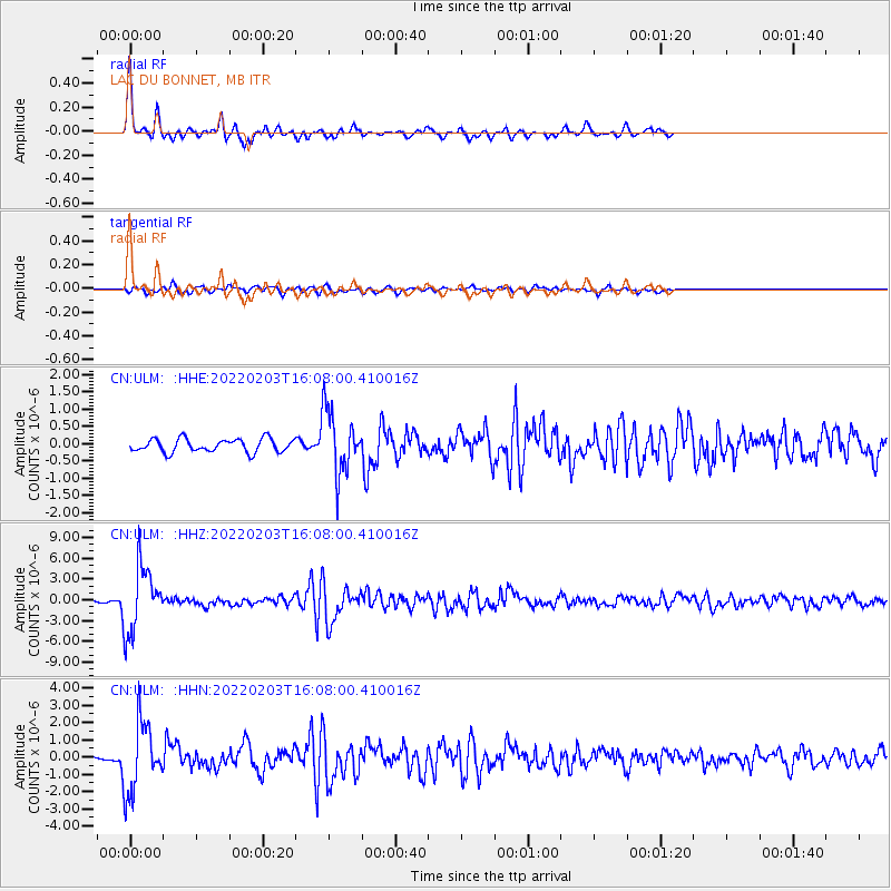
Signal To Noise
| Channel | StoN | STA | LTA |
| CN:ULM: :HHZ:20220203T16:08:00.410016Z | 24.560066 | 4.690917E-6 | 1.9099775E-7 |
| CN:ULM: :HHN:20220203T16:08:00.410016Z | 30.456646 | 1.9961724E-6 | 6.554144E-8 |
| CN:ULM: :HHE:20220203T16:08:00.410016Z | 4.84806 | 9.2009367E-7 | 1.8978594E-7 |
| Arrivals |
| Ps | 4.1 SECOND |
| PpPs | 14 SECOND |
| PsPs/PpSs | 18 SECOND |


