You are here: Home > Network List > GS - US Geological Survey Networks Stations List
> Station KAN13 Rinehart Farm > Earthquake Result Viewer
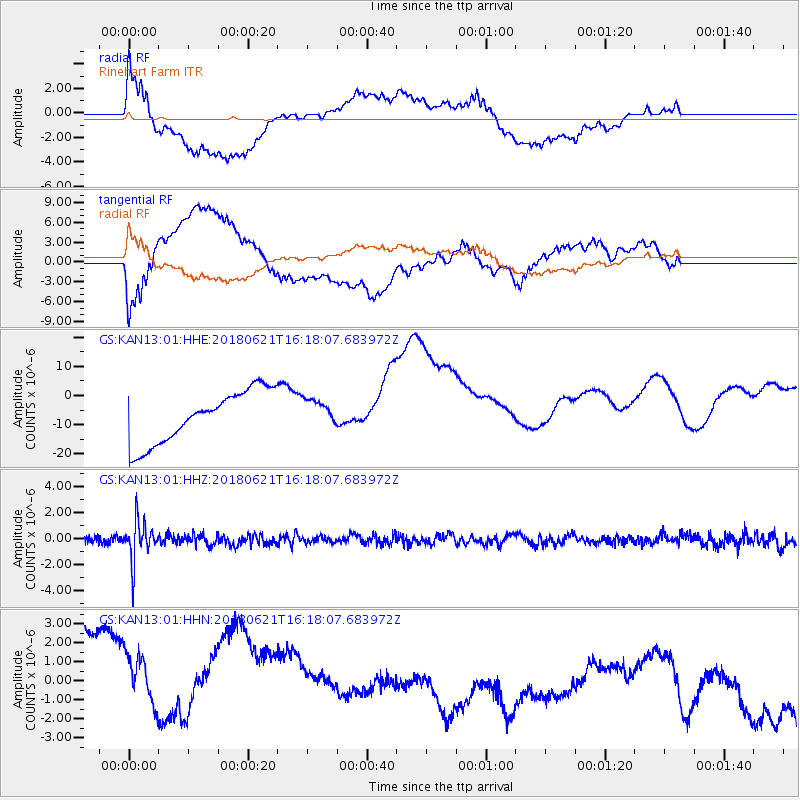
KAN13 Rinehart Farm - Earthquake Result Viewer
*The percent match for this event was below the threshold and hence no stack was calculated.
| Earthquake location: |
Chile-Argentina Border Region |
| Earthquake latitude/longitude: |
-24.3/-67.1 |
| Earthquake time(UTC): |
2018/06/21 (172) 16:08:02 GMT |
| Earthquake Depth: |
175 km |
| Earthquake Magnitude: |
5.7 Mww |
| Earthquake Catalog/Contributor: |
NEIC PDE/us |
|
| Network: |
GS US Geological Survey Networks |
| Station: |
KAN13 Rinehart Farm |
| Lat/Lon: |
37.01 N/97.48 W |
| Elevation: |
340 m |
|
| Distance: |
67.4 deg |
| Az: |
333.965 deg |
| Baz: |
149.983 deg |
| Ray Param: |
$rayparam |
*The percent match for this event was below the threshold and hence was not used in the summary stack. |
|
| Radial Match: |
64.7412 % |
| Radial Bump: |
400 |
| Transverse Match: |
44.12716 % |
| Transverse Bump: |
400 |
| SOD ConfigId: |
2709371 |
| Insert Time: |
2018-07-05 16:11:55.741 +0000 |
| GWidth: |
2.5 |
| Max Bumps: |
400 |
| Tol: |
0.001 |
|
Signal To Noise
| Channel | StoN | STA | LTA |
| GS:KAN13:01:HHZ:20180621T16:18:07.683972Z | 8.719048 | 1.4843396E-6 | 1.7024102E-7 |
| GS:KAN13:01:HHN:20180621T16:18:07.683972Z | 0.7150612 | 5.771621E-6 | 8.071506E-6 |
| GS:KAN13:01:HHE:20180621T16:18:07.683972Z | 0.52613986 | 4.675553E-6 | 8.886522E-6 |
| Arrivals |
| Ps | |
| PpPs | |
| PsPs/PpSs | |


