You are here: Home > Network List > ET - CERI Southern Appalachian seismic Network Stations List
> Station SWET Sewanee,TN > Earthquake Result Viewer
SWET Sewanee,TN - Earthquake Result Viewer
| Earthquake location: |
Northern Peru |
| Earthquake latitude/longitude: |
-4.5/-76.9 |
| Earthquake time(UTC): |
2022/02/03 (034) 15:58:56 GMT |
| Earthquake Depth: |
100 km |
| Earthquake Magnitude: |
6.5 mww |
| Earthquake Catalog/Contributor: |
NEIC PDE/us |
|
| Network: |
ET CERI Southern Appalachian seismic Network |
| Station: |
SWET Sewanee,TN |
| Lat/Lon: |
35.22 N/85.93 W |
| Elevation: |
581 m |
|
| Distance: |
40.4 deg |
| Az: |
348.601 deg |
| Baz: |
166.074 deg |
| Ray Param: |
0.074113 |
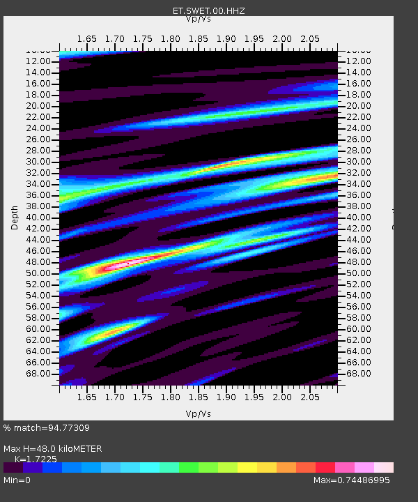
| Estimated Moho Depth: |
48.0 km |
| Estimated Crust Vp/Vs: |
1.72 |
| Assumed Crust Vp: |
6.35 km/s |
| Estimated Crust Vs: |
3.687 km/s |
| Estimated Crust Poisson's Ratio: |
0.25 |
|
| Radial Match: |
94.77309 % |
| Radial Bump: |
396 |
| Transverse Match: |
79.585266 % |
| Transverse Bump: |
400 |
| SOD ConfigId: |
26694651 |
| Insert Time: |
2022-02-17 16:17:21.838 +0000 |
| GWidth: |
2.5 |
| Max Bumps: |
400 |
| Tol: |
0.001 |
|

Signal To Noise
| Channel | StoN | STA | LTA |
| ET:SWET:00:HHZ:20220203T16:05:54.079999Z | 31.650333 | 5.330172E-6 | 1.6840808E-7 |
| ET:SWET:00:HHN:20220203T16:05:54.079999Z | 28.916786 | 3.403552E-6 | 1.17701596E-7 |
| ET:SWET:00:HHE:20220203T16:05:54.079999Z | 4.2541323 | 5.8878294E-7 | 1.3840258E-7 |
| Arrivals |
| Ps | 5.9 SECOND |
| PpPs | 19 SECOND |
| PsPs/PpSs | 25 SECOND |


