You are here: Home > Network List > MN - MEDNET Project Stations List
> Station AQU L'Aquila, Italy > Earthquake Result Viewer
AQU L'Aquila, Italy - Earthquake Result Viewer
| Earthquake location: |
Northern Sumatra, Indonesia |
| Earthquake latitude/longitude: |
3.4/99.1 |
| Earthquake time(UTC): |
2006/12/01 (335) 03:58:21 GMT |
| Earthquake Depth: |
206 km |
| Earthquake Magnitude: |
6.0 MB, 6.3 MW, 6.3 MW |
| Earthquake Catalog/Contributor: |
WHDF/NEIC |
|
| Network: |
MN MEDNET Project |
| Station: |
AQU L'Aquila, Italy |
| Lat/Lon: |
42.35 N/13.40 E |
| Elevation: |
710 m |
|
| Distance: |
84.5 deg |
| Az: |
312.054 deg |
| Baz: |
90.393 deg |
| Ray Param: |
0.044916563 |
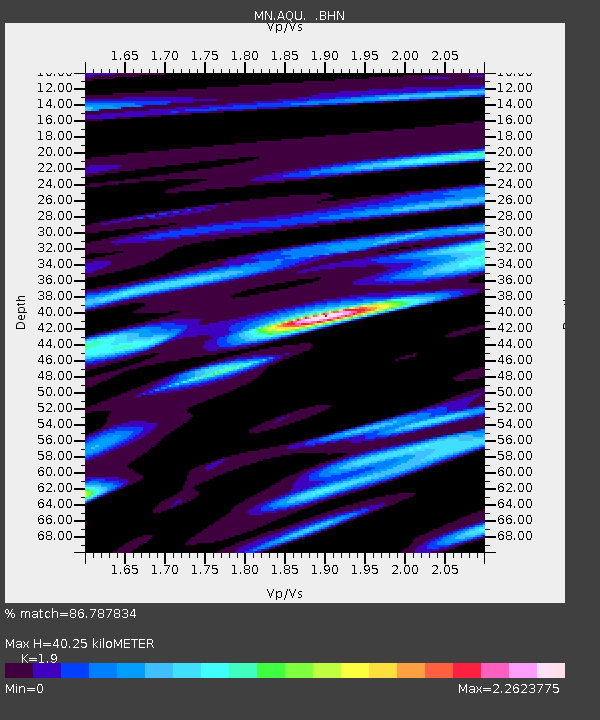
| Estimated Moho Depth: |
40.25 km |
| Estimated Crust Vp/Vs: |
1.90 |
| Assumed Crust Vp: |
6.276 km/s |
| Estimated Crust Vs: |
3.303 km/s |
| Estimated Crust Poisson's Ratio: |
0.31 |
|
| Radial Match: |
86.787834 % |
| Radial Bump: |
400 |
| Transverse Match: |
84.14147 % |
| Transverse Bump: |
400 |
| SOD ConfigId: |
2564 |
| Insert Time: |
2010-02-26 16:21:11.878 +0000 |
| GWidth: |
2.5 |
| Max Bumps: |
400 |
| Tol: |
0.001 |
|
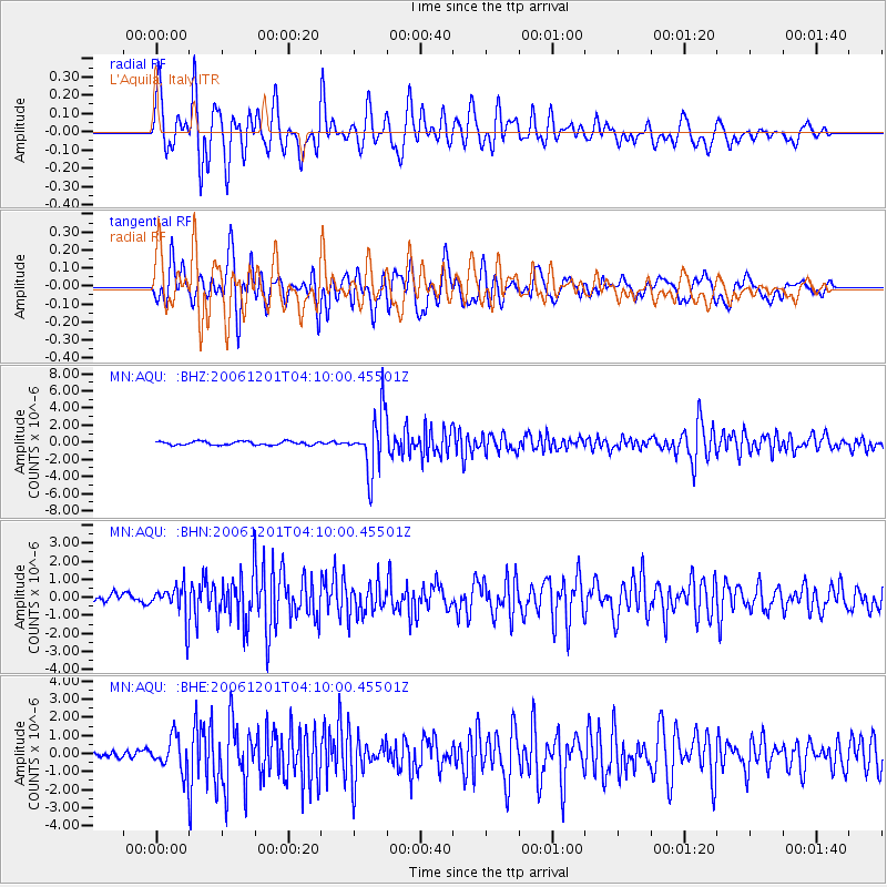
Signal To Noise
| Channel | StoN | STA | LTA |
| MN:AQU: :BHN:20061201T04:10:00.45501Z | 2.5334847 | 9.73966E-7 | 3.844373E-7 |
| MN:AQU: :BHE:20061201T04:10:00.45501Z | 3.7971578 | 9.593351E-7 | 2.5264555E-7 |
| MN:AQU: :BHZ:20061201T04:10:00.45501Z | 16.428415 | 3.3852768E-6 | 2.0606231E-7 |
| Arrivals |
| Ps | 5.9 SECOND |
| PpPs | 18 SECOND |
| PsPs/PpSs | 24 SECOND |


