You are here: Home > Network List > GM - US Geological Survey Networks Stations List
> Station NMP01 New Mexico Permian - Site# 01 > Earthquake Result Viewer
NMP01 New Mexico Permian - Site# 01 - Earthquake Result Viewer
| Earthquake location: |
Northern Peru |
| Earthquake latitude/longitude: |
-4.5/-76.9 |
| Earthquake time(UTC): |
2022/02/03 (034) 15:58:56 GMT |
| Earthquake Depth: |
100 km |
| Earthquake Magnitude: |
6.5 mww |
| Earthquake Catalog/Contributor: |
NEIC PDE/us |
|
| Network: |
GM US Geological Survey Networks |
| Station: |
NMP01 New Mexico Permian - Site# 01 |
| Lat/Lon: |
32.20 N/103.86 W |
| Elevation: |
1048 m |
|
| Distance: |
44.5 deg |
| Az: |
326.826 deg |
| Baz: |
139.944 deg |
| Ray Param: |
0.07152019 |
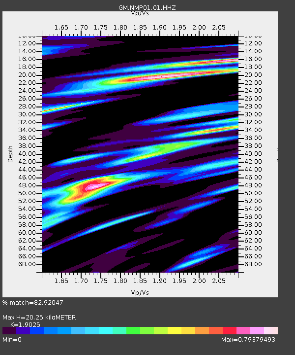
| Estimated Moho Depth: |
20.25 km |
| Estimated Crust Vp/Vs: |
1.90 |
| Assumed Crust Vp: |
6.129 km/s |
| Estimated Crust Vs: |
3.221 km/s |
| Estimated Crust Poisson's Ratio: |
0.31 |
|
| Radial Match: |
82.92047 % |
| Radial Bump: |
400 |
| Transverse Match: |
76.22535 % |
| Transverse Bump: |
400 |
| SOD ConfigId: |
26694651 |
| Insert Time: |
2022-02-17 16:18:34.571 +0000 |
| GWidth: |
2.5 |
| Max Bumps: |
400 |
| Tol: |
0.001 |
|

Signal To Noise
| Channel | StoN | STA | LTA |
| GM:NMP01:01:HHZ:20220203T16:06:27.925Z | 37.327633 | 5.0485246E-6 | 1.3524898E-7 |
| GM:NMP01:01:HHN:20220203T16:06:27.925Z | 11.051522 | 1.8486139E-6 | 1.6727233E-7 |
| GM:NMP01:01:HHE:20220203T16:06:27.925Z | 11.562414 | 2.1594326E-6 | 1.8676312E-7 |
| Arrivals |
| Ps | 3.1 SECOND |
| PpPs | 9.1 SECOND |
| PsPs/PpSs | 12 SECOND |


