You are here: Home > Network List > GM - US Geological Survey Networks Stations List
> Station NMP35 New Mexico Permian - Site# W3S5 > Earthquake Result Viewer
NMP35 New Mexico Permian - Site# W3S5 - Earthquake Result Viewer
| Earthquake location: |
Northern Peru |
| Earthquake latitude/longitude: |
-4.5/-76.9 |
| Earthquake time(UTC): |
2022/02/03 (034) 15:58:56 GMT |
| Earthquake Depth: |
100 km |
| Earthquake Magnitude: |
6.5 mww |
| Earthquake Catalog/Contributor: |
NEIC PDE/us |
|
| Network: |
GM US Geological Survey Networks |
| Station: |
NMP35 New Mexico Permian - Site# W3S5 |
| Lat/Lon: |
32.35 N/103.72 W |
| Elevation: |
1071 m |
|
| Distance: |
44.6 deg |
| Az: |
327.086 deg |
| Baz: |
140.202 deg |
| Ray Param: |
0.07149513 |
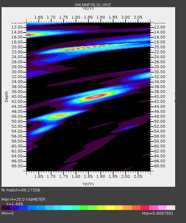
| Estimated Moho Depth: |
20.0 km |
| Estimated Crust Vp/Vs: |
1.85 |
| Assumed Crust Vp: |
6.129 km/s |
| Estimated Crust Vs: |
3.322 km/s |
| Estimated Crust Poisson's Ratio: |
0.29 |
|
| Radial Match: |
88.17206 % |
| Radial Bump: |
400 |
| Transverse Match: |
70.6683 % |
| Transverse Bump: |
400 |
| SOD ConfigId: |
26694651 |
| Insert Time: |
2022-02-17 16:18:44.883 +0000 |
| GWidth: |
2.5 |
| Max Bumps: |
400 |
| Tol: |
0.001 |
|

Signal To Noise
| Channel | StoN | STA | LTA |
| GM:NMP35:01:HHZ:20220203T16:06:28.234998Z | 24.482609 | 4.6776036E-6 | 1.9105822E-7 |
| GM:NMP35:01:HHN:20220203T16:06:28.234998Z | 4.726417 | 1.2928301E-6 | 2.735328E-7 |
| GM:NMP35:01:HHE:20220203T16:06:28.234998Z | 11.94958 | 1.423828E-6 | 1.1915298E-7 |
| Arrivals |
| Ps | 2.9 SECOND |
| PpPs | 8.8 SECOND |
| PsPs/PpSs | 12 SECOND |


