You are here: Home > Network List > GM - US Geological Survey Networks Stations List
> Station NMP44 New Mexico Permian - Site# W4S4 > Earthquake Result Viewer
NMP44 New Mexico Permian - Site# W4S4 - Earthquake Result Viewer
| Earthquake location: |
Northern Peru |
| Earthquake latitude/longitude: |
-4.5/-76.9 |
| Earthquake time(UTC): |
2022/02/03 (034) 15:58:56 GMT |
| Earthquake Depth: |
100 km |
| Earthquake Magnitude: |
6.5 mww |
| Earthquake Catalog/Contributor: |
NEIC PDE/us |
|
| Network: |
GM US Geological Survey Networks |
| Station: |
NMP44 New Mexico Permian - Site# W4S4 |
| Lat/Lon: |
32.20 N/103.62 W |
| Elevation: |
1086 m |
|
| Distance: |
44.4 deg |
| Az: |
327.05 deg |
| Baz: |
140.232 deg |
| Ray Param: |
0.071602456 |
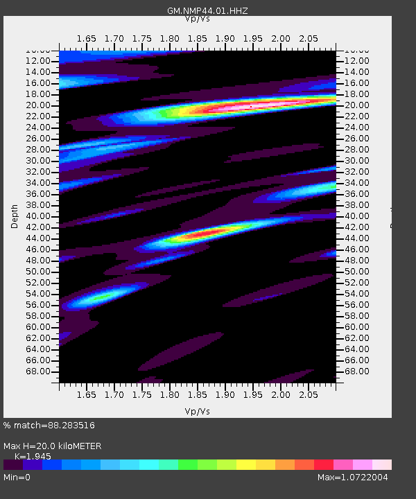
| Estimated Moho Depth: |
20.0 km |
| Estimated Crust Vp/Vs: |
1.95 |
| Assumed Crust Vp: |
6.129 km/s |
| Estimated Crust Vs: |
3.151 km/s |
| Estimated Crust Poisson's Ratio: |
0.32 |
|
| Radial Match: |
88.283516 % |
| Radial Bump: |
400 |
| Transverse Match: |
70.9889 % |
| Transverse Bump: |
400 |
| SOD ConfigId: |
26694651 |
| Insert Time: |
2022-02-17 16:18:48.075 +0000 |
| GWidth: |
2.5 |
| Max Bumps: |
400 |
| Tol: |
0.001 |
|

Signal To Noise
| Channel | StoN | STA | LTA |
| GM:NMP44:01:HHZ:20220203T16:06:26.884992Z | 26.109098 | 4.552324E-6 | 1.7435777E-7 |
| GM:NMP44:01:HHN:20220203T16:06:26.884992Z | 8.470194 | 1.3284766E-6 | 1.5684134E-7 |
| GM:NMP44:01:HHE:20220203T16:06:26.884992Z | 7.582302 | 1.5159459E-6 | 1.9993215E-7 |
| Arrivals |
| Ps | 3.3 SECOND |
| PpPs | 9.1 SECOND |
| PsPs/PpSs | 12 SECOND |


