You are here: Home > Network List > GS - US Geological Survey Networks Stations List
> Station ASA2 ASA2 > Earthquake Result Viewer
ASA2 ASA2 - Earthquake Result Viewer
| Earthquake location: |
Northern Peru |
| Earthquake latitude/longitude: |
-4.5/-76.9 |
| Earthquake time(UTC): |
2022/02/03 (034) 15:58:56 GMT |
| Earthquake Depth: |
100 km |
| Earthquake Magnitude: |
6.5 mww |
| Earthquake Catalog/Contributor: |
NEIC PDE/us |
|
| Network: |
GS US Geological Survey Networks |
| Station: |
ASA2 ASA2 |
| Lat/Lon: |
34.95 N/106.46 W |
| Elevation: |
1830 m |
|
| Distance: |
48.0 deg |
| Az: |
327.015 deg |
| Baz: |
138.644 deg |
| Ray Param: |
0.06929718 |
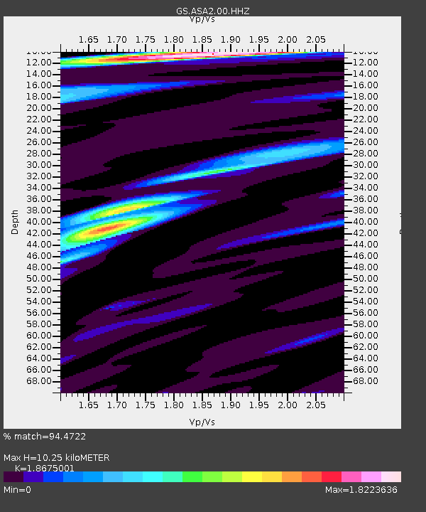
| Estimated Moho Depth: |
10.25 km |
| Estimated Crust Vp/Vs: |
1.87 |
| Assumed Crust Vp: |
6.502 km/s |
| Estimated Crust Vs: |
3.481 km/s |
| Estimated Crust Poisson's Ratio: |
0.30 |
|
| Radial Match: |
94.4722 % |
| Radial Bump: |
400 |
| Transverse Match: |
84.518295 % |
| Transverse Bump: |
400 |
| SOD ConfigId: |
26694651 |
| Insert Time: |
2022-02-17 16:19:03.109 +0000 |
| GWidth: |
2.5 |
| Max Bumps: |
400 |
| Tol: |
0.001 |
|

Signal To Noise
| Channel | StoN | STA | LTA |
| GS:ASA2:00:HHZ:20220203T16:06:55.168988Z | 26.406591 | 3.9924985E-6 | 1.5119325E-7 |
| GS:ASA2:00:HH1:20220203T16:06:55.168988Z | 25.324709 | 1.9181641E-6 | 7.574279E-8 |
| GS:ASA2:00:HH2:20220203T16:06:55.168988Z | 15.114076 | 1.6237054E-6 | 1.07430026E-7 |
| Arrivals |
| Ps | 1.4 SECOND |
| PpPs | 4.3 SECOND |
| PsPs/PpSs | 5.7 SECOND |


