You are here: Home > Network List > GT - Global Telemetered Seismograph Network (USAF/USGS) Stations List
> Station PLCA Paso Flores, Argentina > Earthquake Result Viewer
PLCA Paso Flores, Argentina - Earthquake Result Viewer
| Earthquake location: |
Northern Peru |
| Earthquake latitude/longitude: |
-4.5/-76.9 |
| Earthquake time(UTC): |
2022/02/03 (034) 15:58:56 GMT |
| Earthquake Depth: |
100 km |
| Earthquake Magnitude: |
6.5 mww |
| Earthquake Catalog/Contributor: |
NEIC PDE/us |
|
| Network: |
GT Global Telemetered Seismograph Network (USAF/USGS) |
| Station: |
PLCA Paso Flores, Argentina |
| Lat/Lon: |
40.73 S/70.55 W |
| Elevation: |
1080 m |
|
| Distance: |
36.6 deg |
| Az: |
171.841 deg |
| Baz: |
349.269 deg |
| Ray Param: |
0.07630408 |
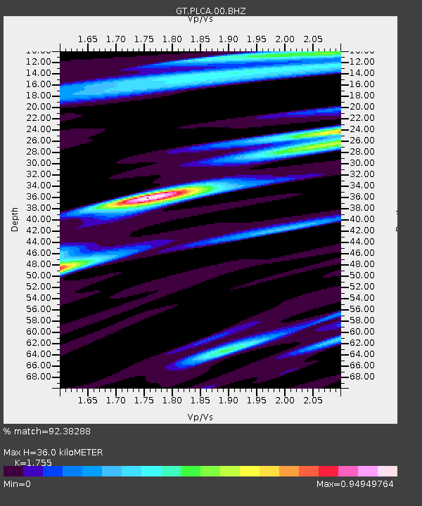
| Estimated Moho Depth: |
36.0 km |
| Estimated Crust Vp/Vs: |
1.75 |
| Assumed Crust Vp: |
6.597 km/s |
| Estimated Crust Vs: |
3.759 km/s |
| Estimated Crust Poisson's Ratio: |
0.26 |
|
| Radial Match: |
92.38288 % |
| Radial Bump: |
375 |
| Transverse Match: |
74.43464 % |
| Transverse Bump: |
400 |
| SOD ConfigId: |
26694651 |
| Insert Time: |
2022-02-17 16:19:35.750 +0000 |
| GWidth: |
2.5 |
| Max Bumps: |
400 |
| Tol: |
0.001 |
|

Signal To Noise
| Channel | StoN | STA | LTA |
| GT:PLCA:00:BHZ:20220203T16:05:22.474011Z | 14.427317 | 3.7532848E-6 | 2.6015127E-7 |
| GT:PLCA:00:BHN:20220203T16:05:22.474011Z | 16.9939 | 2.1383364E-6 | 1.2582964E-7 |
| GT:PLCA:00:BHE:20220203T16:05:22.474011Z | 2.2996287 | 4.742869E-7 | 2.06245E-7 |
| Arrivals |
| Ps | 4.5 SECOND |
| PpPs | 14 SECOND |
| PsPs/PpSs | 18 SECOND |


