You are here: Home > Network List > IE - INL Seismic Monitoring Program Stations List
> Station BCYI Bear Canyon, Idaho, USA > Earthquake Result Viewer
BCYI Bear Canyon, Idaho, USA - Earthquake Result Viewer
| Earthquake location: |
Northern Peru |
| Earthquake latitude/longitude: |
-4.5/-76.9 |
| Earthquake time(UTC): |
2022/02/03 (034) 15:58:56 GMT |
| Earthquake Depth: |
100 km |
| Earthquake Magnitude: |
6.5 mww |
| Earthquake Catalog/Contributor: |
NEIC PDE/us |
|
| Network: |
IE INL Seismic Monitoring Program |
| Station: |
BCYI Bear Canyon, Idaho, USA |
| Lat/Lon: |
44.31 N/113.41 W |
| Elevation: |
2194 m |
|
| Distance: |
58.5 deg |
| Az: |
329.986 deg |
| Baz: |
135.998 deg |
| Ray Param: |
0.062487848 |
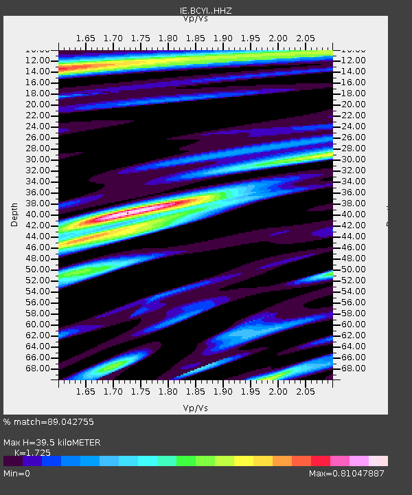
| Estimated Moho Depth: |
39.5 km |
| Estimated Crust Vp/Vs: |
1.73 |
| Assumed Crust Vp: |
6.577 km/s |
| Estimated Crust Vs: |
3.813 km/s |
| Estimated Crust Poisson's Ratio: |
0.25 |
|
| Radial Match: |
89.042755 % |
| Radial Bump: |
400 |
| Transverse Match: |
86.653114 % |
| Transverse Bump: |
400 |
| SOD ConfigId: |
26694651 |
| Insert Time: |
2022-02-17 16:20:03.774 +0000 |
| GWidth: |
2.5 |
| Max Bumps: |
400 |
| Tol: |
0.001 |
|

Signal To Noise
| Channel | StoN | STA | LTA |
| IE:BCYI: :HHZ:20220203T16:08:11.960004Z | 34.165108 | 3.2584126E-6 | 9.537253E-8 |
| IE:BCYI: :HHN:20220203T16:08:11.960004Z | 8.199131 | 1.0379013E-6 | 1.2658674E-7 |
| IE:BCYI: :HHE:20220203T16:08:11.960004Z | 9.856716 | 9.476558E-7 | 9.6143154E-8 |
| Arrivals |
| Ps | 4.6 SECOND |
| PpPs | 16 SECOND |
| PsPs/PpSs | 20 SECOND |


