You are here: Home > Network List > IU - Global Seismograph Network (GSN - IRIS/USGS) Stations List
> Station QSPA South Pole Remote Earth Science Observatory (Quiet Zone) > Earthquake Result Viewer
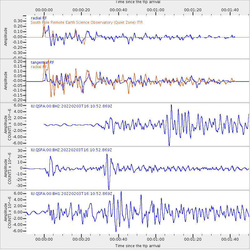
QSPA South Pole Remote Earth Science Observatory (Quiet Zone) - Earthquake Result Viewer

| Earthquake location: |
Northern Peru |
| Earthquake latitude/longitude: |
-4.5/-76.9 |
| Earthquake time(UTC): |
2022/02/03 (034) 15:58:56 GMT |
| Earthquake Depth: |
100 km |
| Earthquake Magnitude: |
6.5 mww |
| Earthquake Catalog/Contributor: |
NEIC PDE/us |
|
| Network: |
IU Global Seismograph Network (GSN - IRIS/USGS) |
| Station: |
QSPA South Pole Remote Earth Science Observatory (Quiet Zone) |
| Lat/Lon: |
89.93 S/144.44 E |
| Elevation: |
2850 m |
|
| Distance: |
85.6 deg |
| Az: |
180.047 deg |
| Baz: |
138.626 deg |
| Ray Param: |
0.044422295 |
| Estimated Moho Depth: |
19.25 km |
| Estimated Crust Vp/Vs: |
1.76 |
| Assumed Crust Vp: |
6.193 km/s |
| Estimated Crust Vs: |
3.509 km/s |
| Estimated Crust Poisson's Ratio: |
0.26 |
|
| Radial Match: |
96.2101 % |
| Radial Bump: |
400 |
| Transverse Match: |
95.230125 % |
| Transverse Bump: |
400 |
| SOD ConfigId: |
26694651 |
| Insert Time: |
2022-02-17 16:20:38.074 +0000 |
| GWidth: |
2.5 |
| Max Bumps: |
400 |
| Tol: |
0.001 |
|
Signal To Noise
| Channel | StoN | STA | LTA |
| IU:QSPA:00:BHZ:20220203T16:10:52.869Z | 45.878452 | 9.473141E-6 | 2.0648345E-7 |
| IU:QSPA:00:BH1:20220203T16:10:52.869Z | 4.274173 | 1.0583867E-6 | 2.4762377E-7 |
| IU:QSPA:00:BH2:20220203T16:10:52.869Z | 4.4983454 | 7.130965E-7 | 1.5852417E-7 |
| Arrivals |
| Ps | 2.4 SECOND |
| PpPs | 8.4 SECOND |
| PsPs/PpSs | 11 SECOND |


