You are here: Home > Network List > LM - Michigan State University Seismic Network Stations List
> Station NHBP Nengshka Wabeno, Nottawaseppi Huron Band of the Potawatomi > Earthquake Result Viewer
NHBP Nengshka Wabeno, Nottawaseppi Huron Band of the Potawatomi - Earthquake Result Viewer
| Earthquake location: |
Northern Peru |
| Earthquake latitude/longitude: |
-4.5/-76.9 |
| Earthquake time(UTC): |
2022/02/03 (034) 15:58:56 GMT |
| Earthquake Depth: |
100 km |
| Earthquake Magnitude: |
6.5 mww |
| Earthquake Catalog/Contributor: |
NEIC PDE/us |
|
| Network: |
LM Michigan State University Seismic Network |
| Station: |
NHBP Nengshka Wabeno, Nottawaseppi Huron Band of the Potawatomi |
| Lat/Lon: |
42.10 N/85.27 W |
| Elevation: |
226 m |
|
| Distance: |
46.9 deg |
| Az: |
351.518 deg |
| Baz: |
168.604 deg |
| Ray Param: |
0.06997122 |
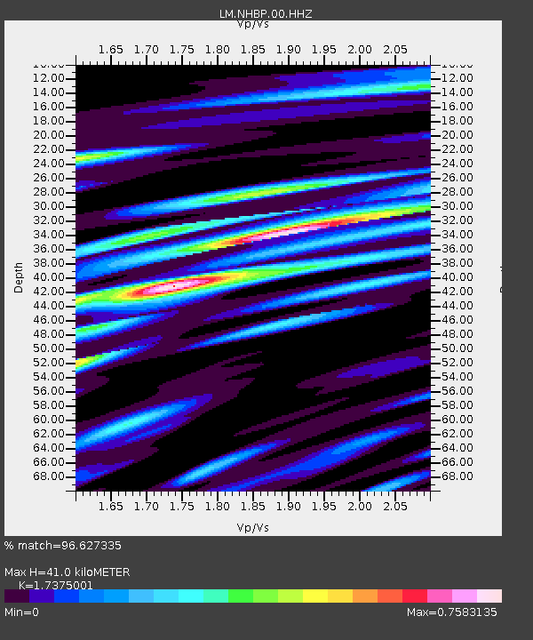
| Estimated Moho Depth: |
41.0 km |
| Estimated Crust Vp/Vs: |
1.74 |
| Assumed Crust Vp: |
6.483 km/s |
| Estimated Crust Vs: |
3.731 km/s |
| Estimated Crust Poisson's Ratio: |
0.25 |
|
| Radial Match: |
96.627335 % |
| Radial Bump: |
259 |
| Transverse Match: |
82.56601 % |
| Transverse Bump: |
400 |
| SOD ConfigId: |
26694651 |
| Insert Time: |
2022-02-17 16:21:38.470 +0000 |
| GWidth: |
2.5 |
| Max Bumps: |
400 |
| Tol: |
0.001 |
|

Signal To Noise
| Channel | StoN | STA | LTA |
| LM:NHBP:00:HHZ:20220203T16:06:46.800Z | 38.176365 | 6.7462574E-6 | 1.7671293E-7 |
| LM:NHBP:00:HHN:20220203T16:06:46.800Z | 23.76333 | 3.7027626E-6 | 1.5581834E-7 |
| LM:NHBP:00:HHE:20220203T16:06:46.800Z | 6.221096 | 1.2627737E-6 | 2.0298252E-7 |
| Arrivals |
| Ps | 5.0 SECOND |
| PpPs | 16 SECOND |
| PsPs/PpSs | 21 SECOND |


