You are here: Home > Network List > MB - Montana Regional Seismic Network Stations List
> Station SRMT Salmond Ranch > Earthquake Result Viewer
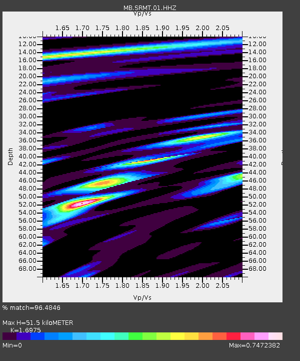
SRMT Salmond Ranch - Earthquake Result Viewer
| Earthquake location: |
Northern Peru |
| Earthquake latitude/longitude: |
-4.5/-76.9 |
| Earthquake time(UTC): |
2022/02/03 (034) 15:58:56 GMT |
| Earthquake Depth: |
100 km |
| Earthquake Magnitude: |
6.5 mww |
| Earthquake Catalog/Contributor: |
NEIC PDE/us |
|
| Network: |
MB Montana Regional Seismic Network |
| Station: |
SRMT Salmond Ranch |
| Lat/Lon: |
47.78 N/112.61 W |
| Elevation: |
1522 m |
|
| Distance: |
60.7 deg |
| Az: |
333.192 deg |
| Baz: |
138.193 deg |
| Ray Param: |
0.061080478 |
| Estimated Moho Depth: |
51.5 km |
| Estimated Crust Vp/Vs: |
1.70 |
| Assumed Crust Vp: |
6.353 km/s |
| Estimated Crust Vs: |
3.743 km/s |
| Estimated Crust Poisson's Ratio: |
0.23 |
|
| Radial Match: |
96.4846 % |
| Radial Bump: |
307 |
| Transverse Match: |
88.521225 % |
| Transverse Bump: |
400 |
| SOD ConfigId: |
26694651 |
| Insert Time: |
2022-02-17 16:21:51.931 +0000 |
| GWidth: |
2.5 |
| Max Bumps: |
400 |
| Tol: |
0.001 |
|

Signal To Noise
| Channel | StoN | STA | LTA |
| MB:SRMT:01:HHZ:20220203T16:08:26.730023Z | 60.448215 | 6.4589317E-6 | 1.06850656E-7 |
| MB:SRMT:01:HHN:20220203T16:08:26.730023Z | 15.875721 | 1.8508811E-6 | 1.1658563E-7 |
| MB:SRMT:01:HHE:20220203T16:08:26.730023Z | 21.293835 | 2.2964111E-6 | 1.0784394E-7 |
| Arrivals |
| Ps | 5.9 SECOND |
| PpPs | 21 SECOND |
| PsPs/PpSs | 27 SECOND |


