You are here: Home > Network List > N4 - Central and EAstern US Network Stations List
> Station G40A Rib Lake, WI, USA > Earthquake Result Viewer
G40A Rib Lake, WI, USA - Earthquake Result Viewer
| Earthquake location: |
Northern Peru |
| Earthquake latitude/longitude: |
-4.5/-76.9 |
| Earthquake time(UTC): |
2022/02/03 (034) 15:58:56 GMT |
| Earthquake Depth: |
100 km |
| Earthquake Magnitude: |
6.5 mww |
| Earthquake Catalog/Contributor: |
NEIC PDE/us |
|
| Network: |
N4 Central and EAstern US Network |
| Station: |
G40A Rib Lake, WI, USA |
| Lat/Lon: |
45.27 N/90.20 W |
| Elevation: |
472 m |
|
| Distance: |
50.9 deg |
| Az: |
347.952 deg |
| Baz: |
162.86 deg |
| Ray Param: |
0.06744471 |
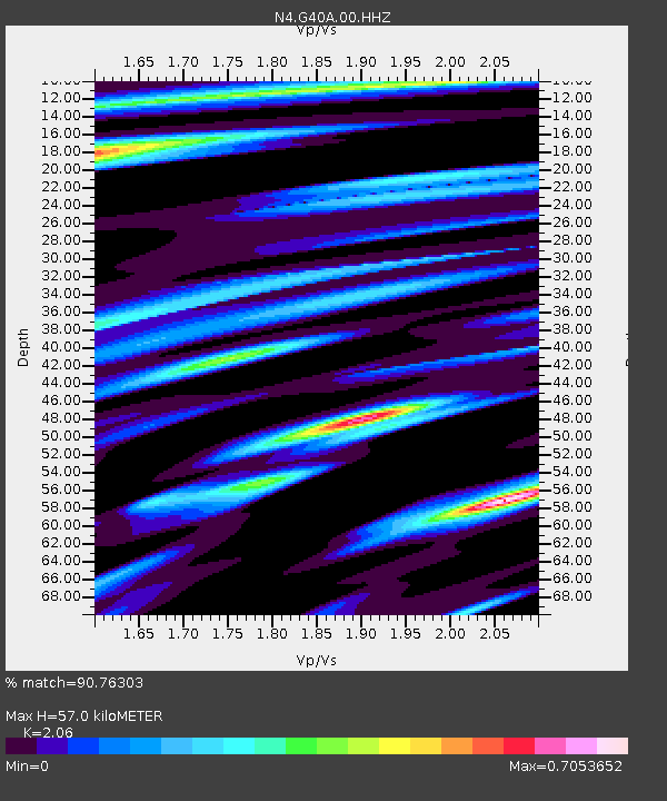
| Estimated Moho Depth: |
57.0 km |
| Estimated Crust Vp/Vs: |
2.06 |
| Assumed Crust Vp: |
6.571 km/s |
| Estimated Crust Vs: |
3.19 km/s |
| Estimated Crust Poisson's Ratio: |
0.35 |
|
| Radial Match: |
90.76303 % |
| Radial Bump: |
271 |
| Transverse Match: |
70.872635 % |
| Transverse Bump: |
400 |
| SOD ConfigId: |
26694651 |
| Insert Time: |
2022-02-17 16:22:47.301 +0000 |
| GWidth: |
2.5 |
| Max Bumps: |
400 |
| Tol: |
0.001 |
|

Signal To Noise
| Channel | StoN | STA | LTA |
| N4:G40A:00:HHZ:20220203T16:07:16.930005Z | 48.437923 | 4.148701E-6 | 8.564985E-8 |
| N4:G40A:00:HH1:20220203T16:07:16.930005Z | 25.24072 | 2.1958238E-6 | 8.6995286E-8 |
| N4:G40A:00:HH2:20220203T16:07:16.930005Z | 6.3357162 | 6.3862694E-7 | 1.00797905E-7 |
| Arrivals |
| Ps | 9.7 SECOND |
| PpPs | 25 SECOND |
| PsPs/PpSs | 35 SECOND |


