You are here: Home > Network List > IU - Global Seismograph Network (GSN - IRIS/USGS) Stations List
> Station RSSD Black Hills, South Dakota, USA > Earthquake Result Viewer
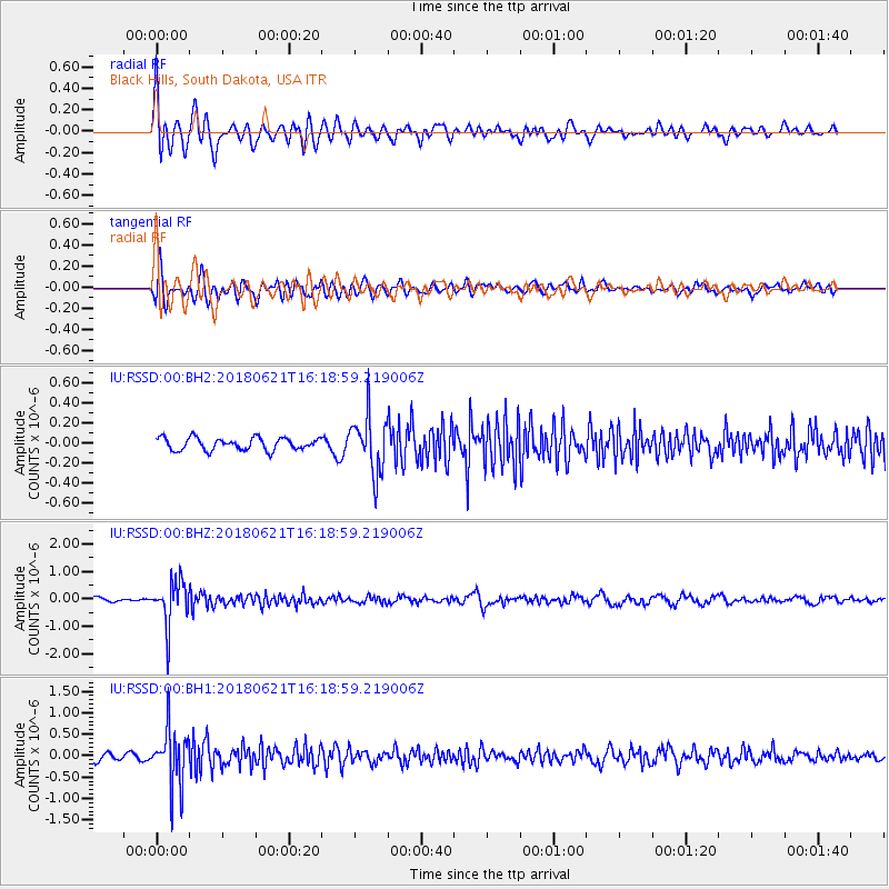
RSSD Black Hills, South Dakota, USA - Earthquake Result Viewer
*The percent match for this event was below the threshold and hence no stack was calculated.
| Earthquake location: |
Chile-Argentina Border Region |
| Earthquake latitude/longitude: |
-24.3/-67.1 |
| Earthquake time(UTC): |
2018/06/21 (172) 16:08:02 GMT |
| Earthquake Depth: |
175 km |
| Earthquake Magnitude: |
5.7 Mww |
| Earthquake Catalog/Contributor: |
NEIC PDE/us |
|
| Network: |
IU Global Seismograph Network (GSN - IRIS/USGS) |
| Station: |
RSSD Black Hills, South Dakota, USA |
| Lat/Lon: |
44.12 N/104.04 W |
| Elevation: |
2090 m |
|
| Distance: |
76.1 deg |
| Az: |
333.495 deg |
| Baz: |
145.576 deg |
| Ray Param: |
$rayparam |
*The percent match for this event was below the threshold and hence was not used in the summary stack. |
|
| Radial Match: |
78.9371 % |
| Radial Bump: |
400 |
| Transverse Match: |
74.898766 % |
| Transverse Bump: |
400 |
| SOD ConfigId: |
2709371 |
| Insert Time: |
2018-07-05 16:13:41.539 +0000 |
| GWidth: |
2.5 |
| Max Bumps: |
400 |
| Tol: |
0.001 |
|
Signal To Noise
| Channel | StoN | STA | LTA |
| IU:RSSD:00:BHZ:20180621T16:18:59.219006Z | 8.620462 | 8.0208775E-7 | 9.3044626E-8 |
| IU:RSSD:00:BH1:20180621T16:18:59.219006Z | 7.8333697 | 6.6084453E-7 | 8.436274E-8 |
| IU:RSSD:00:BH2:20180621T16:18:59.219006Z | 4.6585536 | 2.8183354E-7 | 6.0498074E-8 |
| Arrivals |
| Ps | |
| PpPs | |
| PsPs/PpSs | |


