You are here: Home > Network List > N4 - Central and EAstern US Network Stations List
> Station S39B Bolivar, MO, USA > Earthquake Result Viewer
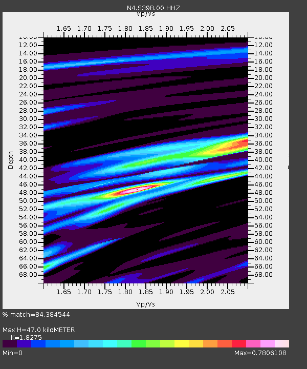
S39B Bolivar, MO, USA - Earthquake Result Viewer
| Earthquake location: |
Northern Peru |
| Earthquake latitude/longitude: |
-4.5/-76.9 |
| Earthquake time(UTC): |
2022/02/03 (034) 15:58:56 GMT |
| Earthquake Depth: |
100 km |
| Earthquake Magnitude: |
6.5 mww |
| Earthquake Catalog/Contributor: |
NEIC PDE/us |
|
| Network: |
N4 Central and EAstern US Network |
| Station: |
S39B Bolivar, MO, USA |
| Lat/Lon: |
37.69 N/93.32 W |
| Elevation: |
340 m |
|
| Distance: |
44.6 deg |
| Az: |
341.422 deg |
| Baz: |
156.397 deg |
| Ray Param: |
0.07147475 |
| Estimated Moho Depth: |
47.0 km |
| Estimated Crust Vp/Vs: |
1.83 |
| Assumed Crust Vp: |
6.53 km/s |
| Estimated Crust Vs: |
3.573 km/s |
| Estimated Crust Poisson's Ratio: |
0.29 |
|
| Radial Match: |
84.384544 % |
| Radial Bump: |
273 |
| Transverse Match: |
71.374916 % |
| Transverse Bump: |
400 |
| SOD ConfigId: |
26694651 |
| Insert Time: |
2022-02-17 16:24:04.917 +0000 |
| GWidth: |
2.5 |
| Max Bumps: |
400 |
| Tol: |
0.001 |
|

Signal To Noise
| Channel | StoN | STA | LTA |
| N4:S39B:00:HHZ:20220203T16:06:28.490003Z | 25.161411 | 3.6066303E-6 | 1.4333975E-7 |
| N4:S39B:00:HH1:20220203T16:06:28.490003Z | 21.685633 | 1.7514301E-6 | 8.0764536E-8 |
| N4:S39B:00:HH2:20220203T16:06:28.490003Z | 8.781754 | 8.639542E-7 | 9.83806E-8 |
| Arrivals |
| Ps | 6.4 SECOND |
| PpPs | 19 SECOND |
| PsPs/PpSs | 25 SECOND |


